I thought I’d compile the posts I’ve written over the years honoring Ossining’s War Veterans. Please note that this is an extremely small selection of the approximately 193 men and women who died in the service of our country, and doesn’t even touch on all those who have served. I also realize, in putting this together, I have so far only written about World War I and II.
But Ossining has had a part in nearly every US conflict, from the Revolutionary War, the War of 1812, the Mexican-American War, the Civil War, the Spanish-American War, WWI & II, the Korean War, the Vietnam War, the Beirut Police Action, the Gulf War, the Iraq War, the Afghanistan War and numerous other police actions and conflicts.
For a more complete list, please refer to this book, published in 1983 by the Ossining Historical Society. (Yes, it does need an update!) I believe a copy can be found in the Ossining Public Library for perusal. One can purchase this from the Ossining Historical Society which, as of this writing on 11/11/2024, is generally open the first Saturday of every month from 10am – 2pm.
We thank each and every person for their service to our country.
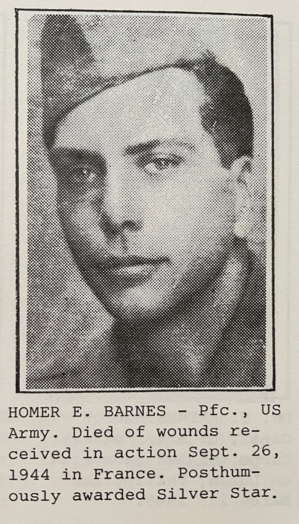
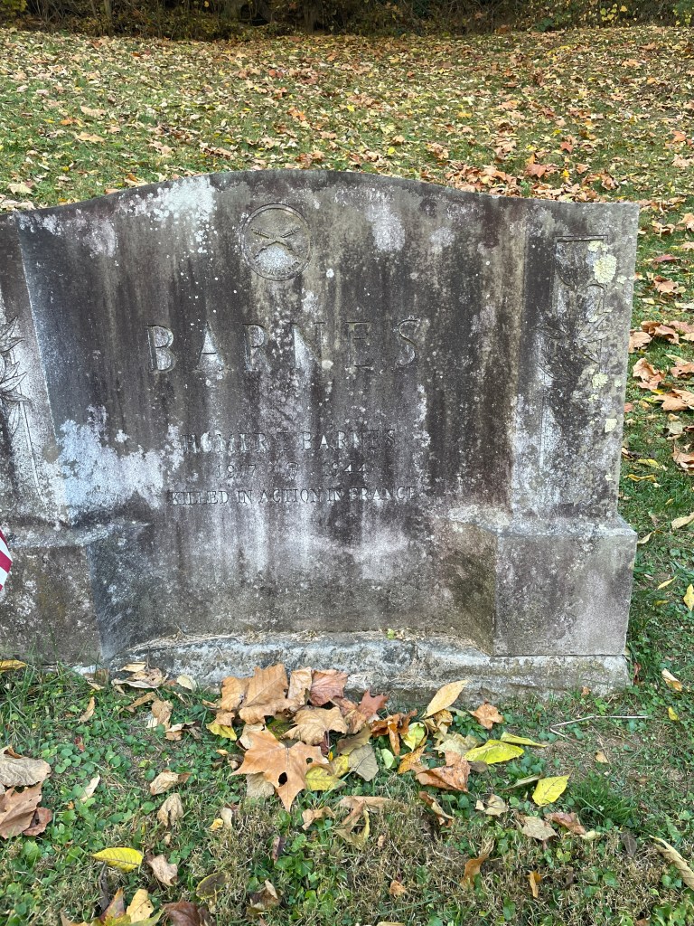
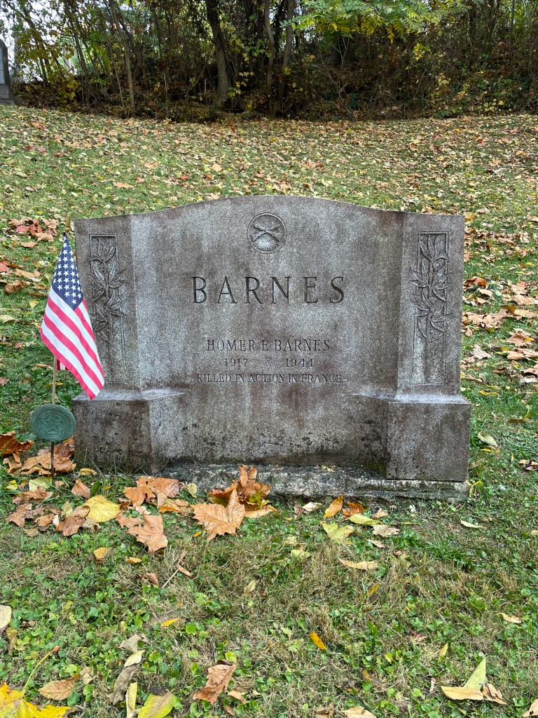
Thanks to the ongoing efforts of the Ossining Historic Cemeteries Conservancy, I recently had the privilege of cleaning this grave, that of Private Homer Barnes, who died in France on September 26, 1944:
I must confess that I chose this grave specifically because it had a Veteran’s flag stuck into the earth in front of it and because the date of death clearly indicated that he had died in WWII. I felt that there was a story to uncover here, and I was not wrong.
Homer Barnes was born in Hamilton, Ontario in 1917 – at the time his father, Dr. Edmund Barnes, was serving as a Major in the Army Medical Corps stationed at Fort Dix during WWI. Homer’s mother had gone home to live with her family while she awaited the birth of her son.
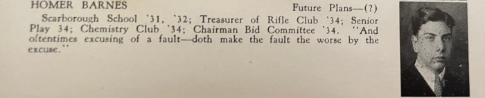
The Barnes family would move to Ossining after the War, and Homer would attend the Scarborough School and then graduate from OHS in 1934.
Courtesy of the 1934 Ossining High School Yearbook
According to his October 23, 1944 obituary published in the Citizen Register, he then attended Pennington Seminary, New York University, and the New York Technical School. The 1940 census has him working as a “chauffeur, self-employed.”
Homer Barnes registered for the draft on October 16, 1940, and was inducted into the service on December 16, 1942[1] at Camp Upton.
He would serve in the 36th Infantry Division, 143rd Infantry Regiment, Company A, 1st Battalion. (I learned all this from the 36th Division Archive, which also notes that his address was 120 North Highland Avenue, Ossining. Today this is the site of Mavis Discount Tire.)
Private First Class Barnes married Ruth Treanor on April 10, 1943 while he was on furlough from Camp Phillips, Kansas to attend his mother’s funeral in Ossining. Ruth would apparently accompany him back to Camp Phillips and stay there until he went overseas on November 1, 1943. PFC Barnes would see some extraordinarily heavy action, first in Italy, then in France.
Now, I’ve never learned much about the Italian campaign of WWII. Just quickly researching PFC Barnes’ Army service has already taught me more than I ever knew about this part of the war, thanks to the detailed after action reports kept (and digitized) by the 36th Infantry Division archive. Here’s a link to the entire thing, if you’re interested.
I’m not yet exactly sure when PFC Barnes entered the field of battle, but the 143rd Infantry Regiment was engaged in some pretty hot fighting in Operation Avalanche, and the Battles of Monte Cassino, and San Pietro during the last few months of 1943.
By February 1944, PFC Barnes had been awarded a Purple Heart for wounds received while crossing the Rapido River near San Angelo, Italy that January. The after-action report for the 36th Infantry offers some excruciating details about this Rapido River offensive:
“Enemy artillery and mortar fire began falling as the first troops reached the river and when Company “A” [PFC Barnes’ company] sent the first wave across, it met with heavy machine gun fire. . . Reports from men who returned the next day indicate that the German machine gun positions were wired in and the bands of fire were interlocking. Many men were wounded in the lower extremities or the buttocks by low grazing fire as they moved or crawled forward.” (52)
PFC Barnes would have shrapnel lodge in his thigh and end up hospitalized for a month after this.
He returned to the front and continued advancing towards Rome with his regiment. The after-action report almost waxes poetic here:
“Never in the entire Italian campaign was there so brilliant a division operation as that employed by the 36th Infantry Division in flanking the enemy bastion at Velletri…. never before in history had the “Eternal City” been captured from the south and as was evidenced by the swiftness with which the enemy was forced to reel back, he was surprised and outwitted by this brilliant maneuver.” (77)
That said, there was deadly fighting throughout, with the German defense “skillfully located and carefully prepared, with first class infantry and strong supporting fire of artillery.” (77)
However, by June 5, 1944 (yes, the day before the Normandy Invasion D-Day!)
“The 143rd Infantry Regiment moved through the city in all available transportation, past the Colosseum, the Ancient Forum, Vatican City and splendid Saint Peter’s Cathedral, through the Arch of Triumph of the Caesars amid cheering throngs of Romans throwing garlands of flowers – greeted as true liberators in a grandiose but sincere reception. No infantryman will forget this experience and he may well be proud to remember it. Following this triumphal turn through Rome, all troops of the 143rd Regiment terminated their gruelling advance, and took a well-deserved rest, bivouacking on the outskirts of the city.” (78)
I sincerely hope that PFC Barnes got to experience this – it must have been rewarding and remarkable. Because after a short break, his regiment would continue to pursue the Germans north. As Captain Douglas Boyd, the Adjutant of the 143rd Infantry Regiment and author of this part of the after-action report writes: “There is no praise too great for the officers and men of the regiment who uncomplainingly, with true soldierly spirit and without regard to self, fought their way those 240 miles in hot pursuit of the enemy.” (90)
After this, PFC Barnes and the 143rd engaged in a Normandy-like invasion of beachheads in Southern France, landing between Cannes (to the north) and Saint-Tropez to the south. PFC Barnes would spend the last month of his life engaged in daily life and death battles, pushing up into the French Alps and encountering stiff resistance from German troops the whole way.
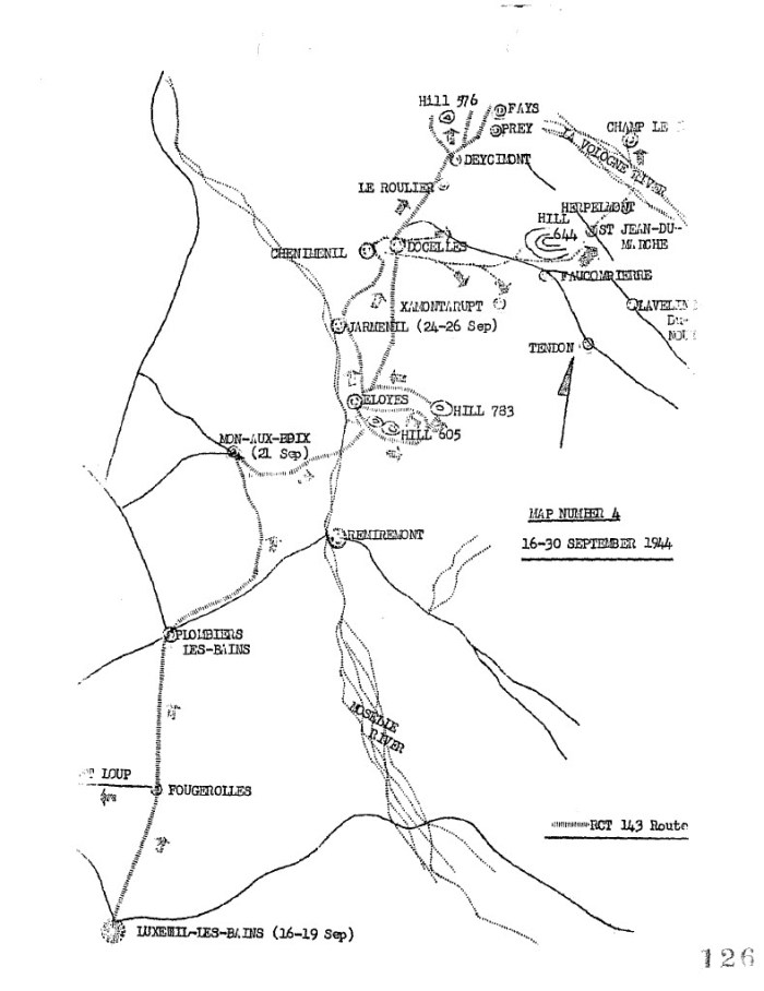
While I can’t be 100% certain, it seems that the last fight PFC Barnes engaged in took place around the Moselle River near a town called Remiremont.
Courtesy of the 36th Division Archive, 143rd Infantry After-Action Reports
The after-action report describes the attack as follows:
“The 143rd began to cross the Moselle River in a column of battalions, the troops waiting and hand carrying their weapons . . . The 1st Battalion – [PFC Barnes’] moved towards its objective, Hill 605 southeast of Eloyes, while under enemy artillery, mortar and machine gun fire. The enemy, approximating battalion strength, engaged the first battalion units in a fierce fire fight. During the night of 21 September 1944, a company of Germans infiltrated Company A’s [PFC Barnes’] positions, and at the dawn of 22nd September, bitter hand to hand fighting ranged until the Germans were cleared.” (133)
PFC Barnes died on 26 September 1944 from wounds received on 22 September, so I’m going to make the assumption that he was wounded in this “bitter hand to hand fighting.”
He would be posthumously awarded the Silver Star for gallantry and this decoration would be presented to his two-year-old son, William E. Barnes.
[1] October 23, 1944 obitiuary published in the Citizen Register
Today’s post will detail the very important cultural ritual of the Polynesian feast, something I was privileged to experience while in Tonga.
First, some context and history . . .
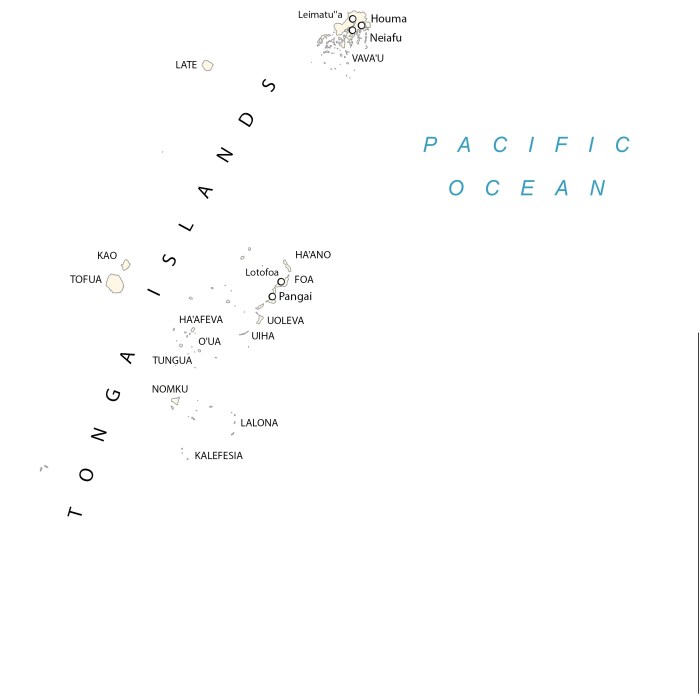
From July 24 – 27, 2024, I was on Vava’u, an island in the Kingdom of Tonga. Tonga is an archipelago that consists of 169 (or so) islands, of which 36 are inhabited. Vava’u is, unsurprisingly, one of the largest islands in the northern Vava’u group.
Interestingly, Tonga is the only Polynesian country that has never been officially colonized. In 1900, it became a British protective state but did not relinquish its power or independence.
Tonga and neighboring Samoa are considered the western gateway to what we call the Polynesian Triangle (which consists of Hawaii to the north, Easter Island to the east and New Zealand to the west.) According to Christina Thompson’s excellent book Sea People, Tonga is where the “oldest languages, longest settlement histories and deepest Polynesian roots” can be found.
It’s believed that Tonga and Samoa have been inhabited for about 2,500 years. Traditional Tongan and Samoan histories tell of an empire that was ruled by Tui Manu’a – both a man and a god. In about 950AD, the first Tu’i Tonga, Aho’eitu (considered the son of god Tangaloa) began expanding his reach, turning Tonga into a superpower that controlled much of what is today’s central Polynesia. Tongan hegemony would hold through the 13th century when civil wars in Tonga and Samoa weakened the empire.
As far as the European presence goes in Tonga, the Dutch first put these islands on maps. First, Schouten and Le Maire stopped here in 1616 (the year William Shakespeare died, just for a bit of context) learning some of the local language while trading for yams, pigs, bananas and fish. In 1642, Dutch explorer Abel Tasman limped through here after his disastrous encounter with the Maori of Aotearoa (New Zealand) and was relieved to note that the islanders in Tonga seemed friendly and eager to trade.
Captain Cook of Great Britain passed through here in 1773 and dubbed them the “Friendly Islands” due to the royal reception he received from the locals. And we can’t forget that the infamous mutiny of the Bounty happened about 30 miles east of the Tongan island of Tofua. Captain Bligh and his 18 loyalists would land their open launch and briefly take shelter in a cave on the northwest coast of Tofua Island. Bligh would write up his report of the mutiny here, as well as a letter to his wife as he directed his men to assess their supplies.
And in April 1840, our US Exploring Expedition briefly stopped at Tongatapu (today considered the main island of Tonga) for about a week. Expedition leader Lt. Charles Wilkes primarily planned to use it as a rendezvous point for his four remaining ships, as some had gone south to explore Antarctica, and some had been in Sydney for repairs.
Unfortunately for us, Wilkes had little interest in the islands, as he was much more concerned with getting to Fiji and securing advantageous treaties for the US regarding the lucrative whaling and bêche de mer industries.
However, while in Nukualofa on Tongatapu, Wilkes inserted himself as a negotiator into a local war between two native groups – the Christians, led by King Josiah (or Tubou) and the (so-called) “Devils,” those who did not follow the Christian teachings of the London Missionary Society. I am hard-pressed to understand Wilkes’ part in a peaceful end to this feud, as his writing on this is as impenetrable as it is condescending. Suffice to say, the disagreement seems to have resolved itself in spite of Wilkes’ meddling. And today Tonga considers itself a Christian nation, with 99% of the population identifying as Christian.
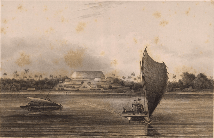
Here’s an illustration by Alfred Agate of the residence of King Josiah (Tubou) on Nukualofa:
Illustration by Alfred Agate from The Narrative of the US Exploring Expedition, volume 3 Courtesy of the Library of Congress
Now, onto feasts!
One of the things that Lt. Charles Wilkes constantly writes about in his Narrative are the feasts and rituals he attended. These could take hours or even days and were essential to attend to meet and connect with the various chiefs and leaders.
And while Wilkes was the big chief of the USXX, other officers were also tapped to attend these feasts in his stead at times. I know that Alfred Agate attended many of these himself, though perhaps not one in Tonga.
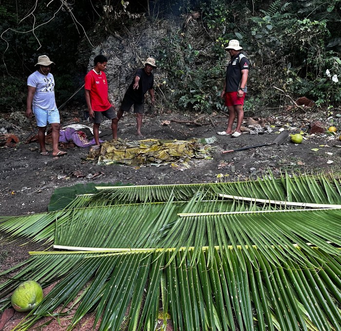
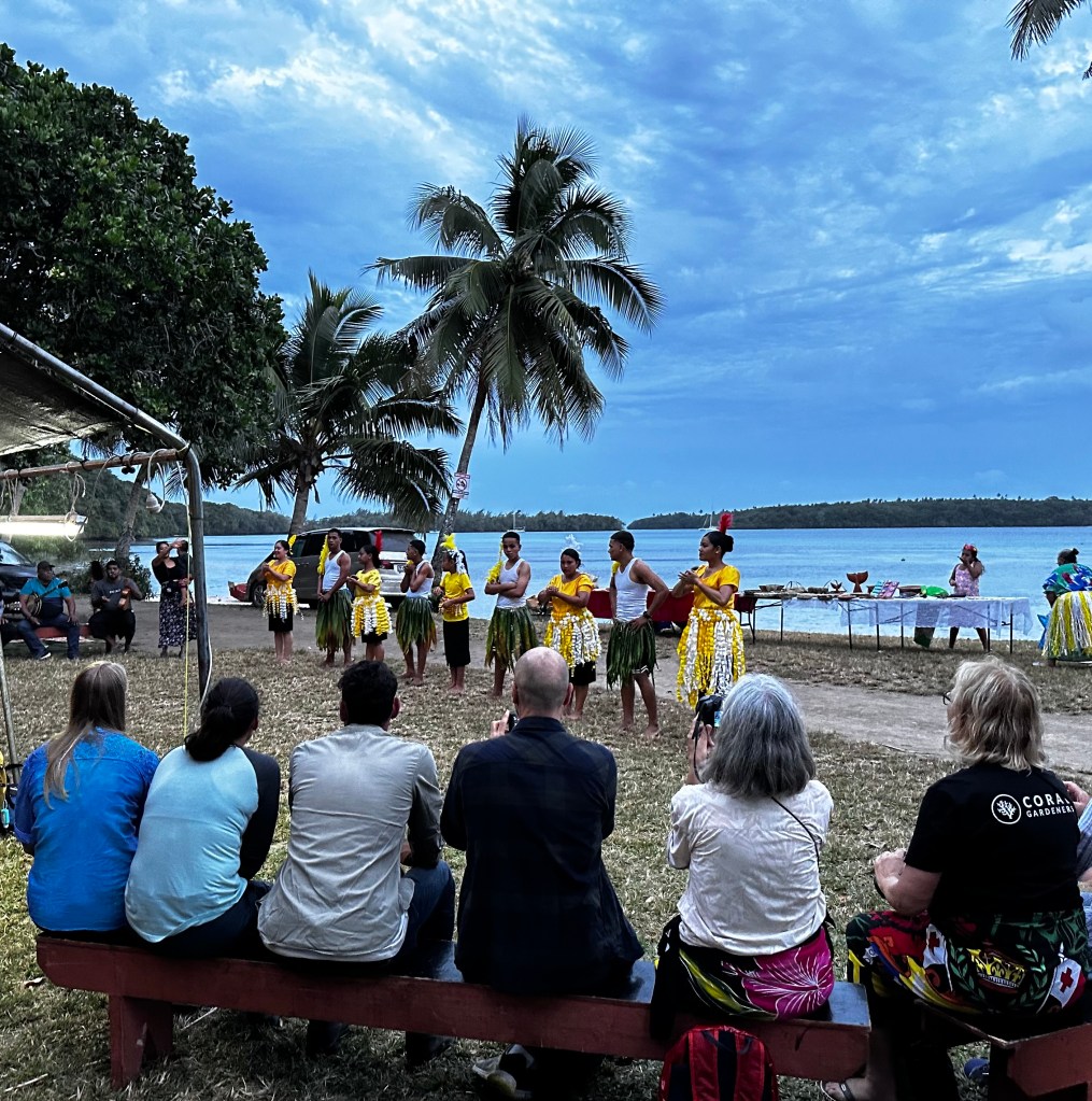
While in Vava’u, I was privileged to beinvited to an umu, a traditional Tongan feast, hosted by Europa crew member Vi Latu and her extended family. As Vi explained to us, this was her family’s way of welcoming us to Tonga.
As we arrived on Ano Beach, the palm trees were gently blowing and the sun was setting. The entire area was taken up with an underground oven, an enormous tent and long table, an area for musicians and dancing, and local artists displaying their crafts.
What’s remarkable, is that many of the traditions on display in 2024 are quite similar to those described by Wilkes in his Narrative. So please indulge me as I’ll describe the traditional feast I attended using lightly edited excerpts from the Narrative of the US South Seas Exploring Expedition (published in 1845), and illustrated with photos from 2024.
Note that what follows is a compilation of observations Wilkes made throughout the South Pacific (primarily Tahiti, Tonga, Samoa, Fiji and Hawaii.) Taken together like this, we get a sense of the deep cultural connection between these Polynesian nations, as well as seeing how the ancient traditions are still intact and observed today.
Wilkes’ observations are italicized below.  Mine are not.

The feast takes many hours to prepare and is generally directed by the women, with the men performing the labor. First, the cooking-place is excavated, a foot deep and about eight feet square:
Traditional Polynesian underground oven, Tongan-style
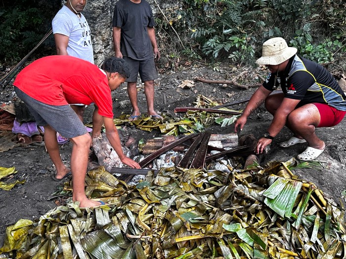
The meat is placed upon hot stones after which taro, yams and coconuts are placed. Finally, it is all covered with banana leaves and earth. After many hours, the oven is unpacked of all its good things . . .
“After many hours, the oven is unpacked of all its good things . . .”
There is an abundance of fish. They likewise have fine crabs, and they are also generous with fowls and pigs.
Their feasts are attended with much ceremony and form . . .
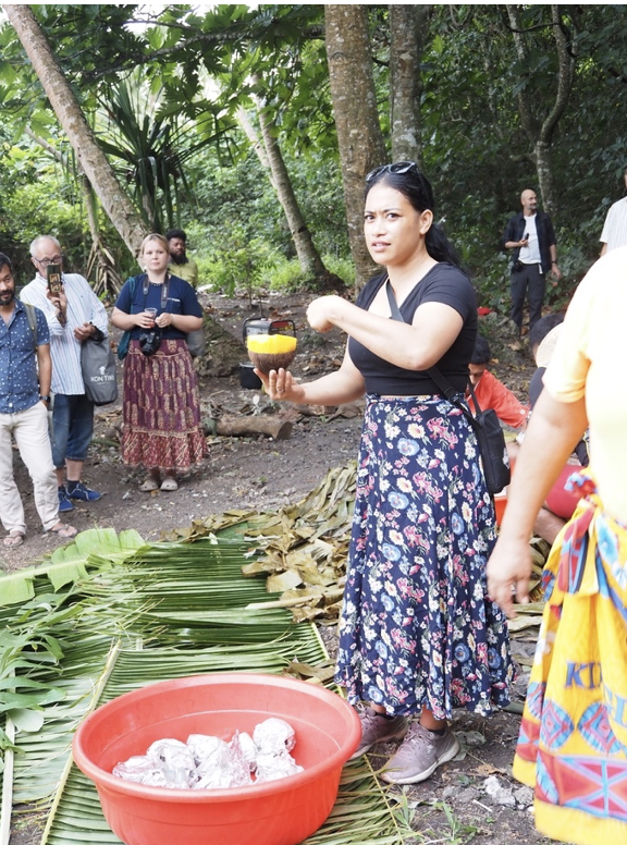
Our feast began with Vi explaining all the delicious foods that were being served to us and how best to eat them.
Vi Latu explaining how to eat papaya and coconut steamed in a coconut shell. Photo courtesy Andrew Willshire
Then we were asked to take our seats at the long table, and the most senior man of Vi’s clan blessed the meal. (I did not feel comfortable taking a photo of this.)
Then, we were encouraged to dig in, using our hands (although forks were provided.)
Photo courtesy Sandy Gale
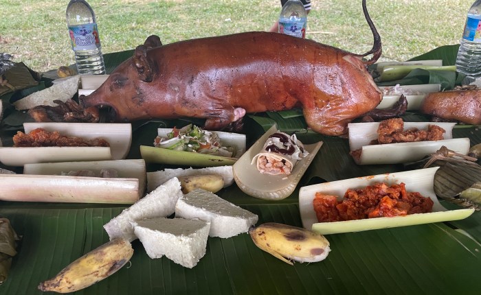
The first course consists of fish, some steamed in banana leaf, and some served in banana trunks. The second course is taro, yams & kumara, with fruit and bananas offered as well. The third and principal course consists of meat – whole piglets are served and then disjointed.
Still the same . . .
The piglet was sliced at the table with a machete. We were encouraged to tear off chunks and enjoy.
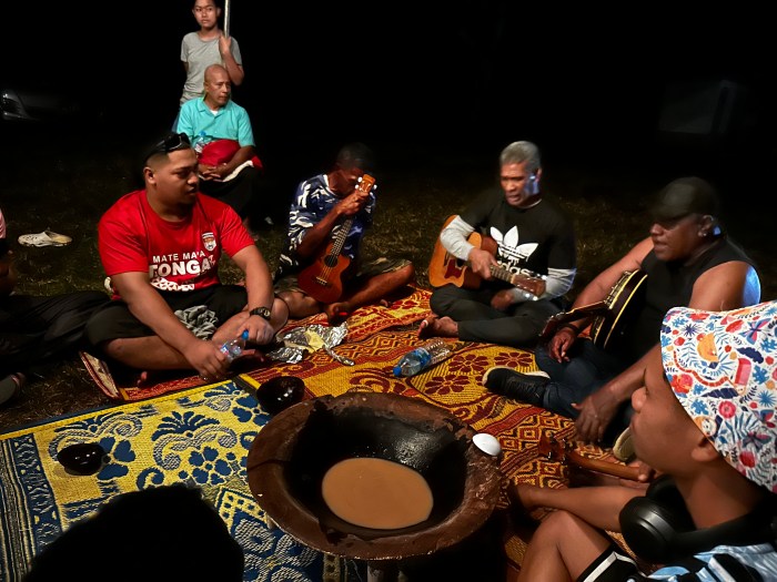
After the third course, dancing, music, stories, and kava-drinking succeed . . .
Dancing . . .
Music and kava.
What is remarkable to me is how little the traditions have changed. One of the only differences I noted between Wilkes' descriptions and what I experienced was that the feast I attended only took four hours.
Also, I think it’s edifying to note that kava, which is a soporific that makes one a bit loopy and anesthetizes the mouth, is no longer prepared in the way Wilkes observed in his Narrative:
The younger women prepare the kava and are required to have clean and undecayed teeth. They are not allowed to swallow any of the juice, on pain of punishment. As soon as the kava-root is chewed, it is spit into the kava-bowl, where water is poured on it with great formality. The king's herald, with a peculiar drawling whine, then cries "Sevu-rui-a-na," (‘make the offering.’) After this, a considerable time is spent in straining the kava through cocoa-nut husks. Kava is made from the Piper mythisticum, and it is the only intoxicating drink they have.
Wilkes in fact refused to drink the kava thus prepared and his hosts, on at least one occasion, gave him coconut water instead. (I feel the need to note that Captain Cook often drank the kava.)  After speaking to Vi, her family and others throughout Polynesia, it’s been reinforced what an important part of the culture kava drinking still is.  Back in the 1840s, refusing to participate fully in a kava ceremony would, I think, have been curious at best and a terrific insult at worst.

Fun fact: Later on, I visited the village of Naseva, on the island of Beqa in Fiji and took part in a traditional kava ceremony where I got to see how the kava is made:
Making kava
Today, dried kava root is ground into a powder then rehydrated and strained through a cloth when needed. Chants are still sung as this takes place.
You’ll note that we are all wearing sarongs and have our shoulders covered.
Wilkes’ description of a kava ceremony in Fiji is completely recognizable to me, as it is quite similar to what I experienced:
The kava-bowl was three feet in diameter. In drinking the kava, the first cup was handed to [the chief], and as there was more in it than he chose to drink, the remainder was poured back into the bowl. The ceremony of clapping of hands was then performed.

We were instructed to clap once before we received the bowl (made of half a coconut shell), then drink the whole thing down, and clap three times after we handed the empty bowl back.  (And yeah, if someone didn't finish their bowl, it was poured back into the big kava bowl. And then served back out.)

And what is kava like?  I cannot tell a lie, I did not enjoy it much – it tastes like it looks, like gritty, muddy water.  And your mouth feels like you’ve just had the rinse the dentist gives you before a root canal.  Other than that, I don’t think I drank enough to feel the full effects . . .  However, I greatly appreciated the ritual and attention to welcoming visitors.  We could all stand to take the time to greet people expansively and properly.

Still more to come . . .

Sign up here if you’re interested in following this 2024 voyage to the South Pacific:
I am back in the 21st century, with access to speedy internet! So, in the next few weeks I will be playing catch up and posting about Tahiti, Tonga and Fiji – all sites our Sparta artist Alfred Agate visited and memorialized on the US Exploring Expedition of 1838 – 1842, and all places that I too visited this July/August of 2024.
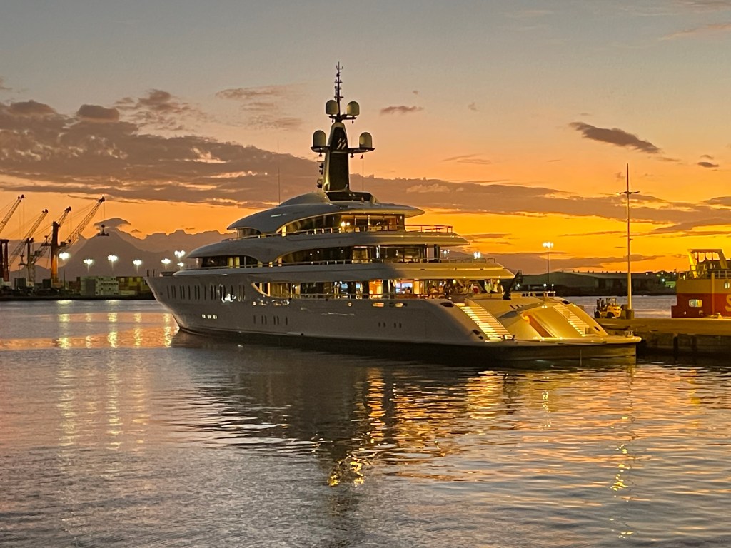
Tahiti!! I joined my ship, the Bark Europa, on July 3, 2024. We were moored in the harbor of Papeete next to a small cruise ship and a couple of giant yachts.
Papeete Harbor 2024 (Alas, you can’t see the Europa in this image.) Courtesy Apple MapsGiant yacht in Papeete Harbor 2024.
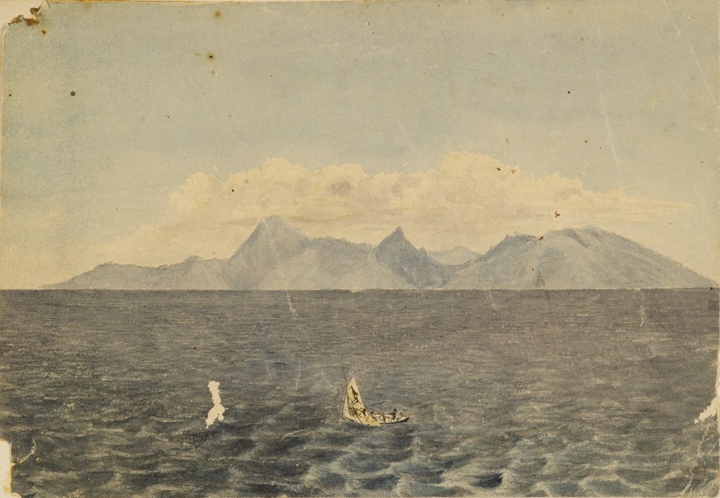
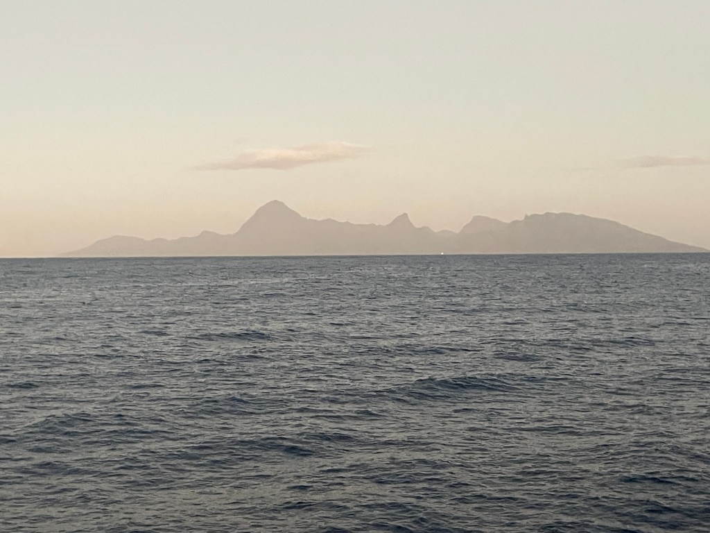
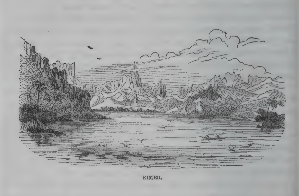
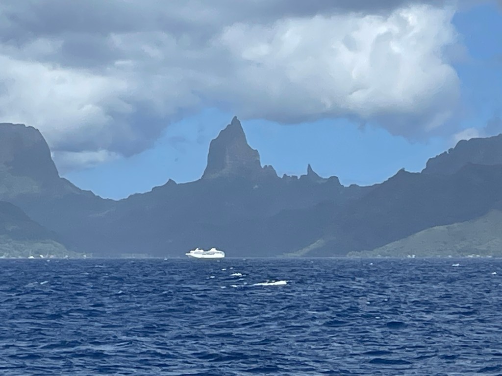
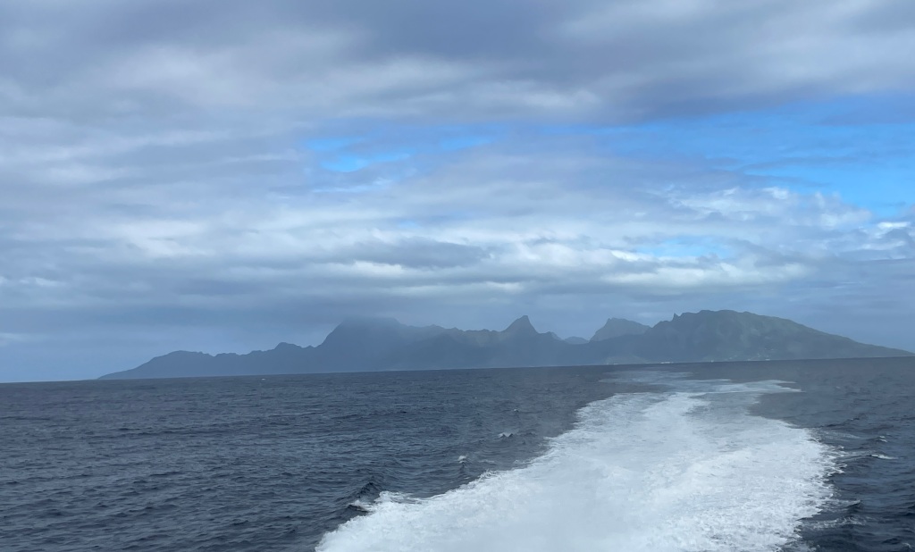
Now, I know I posted these pictures of Eimeo/Moorea before (taken from Papeete), but I continue to be thrilled by this first view that I shared with Alfred Agate, over a 185 years apart:
Eimeo as seen from Papeete, Tahiti, September 1839. Watercolor by Alfred Agate Courtesy of the Smithsonian InstitutionMo’orea (formerly Eimeo) as seen from Papeete, Tahiti, 2024. Photo by John Curvan
In this post I’m going to give a brief history of Tahiti and include more images from Alfred Agate.
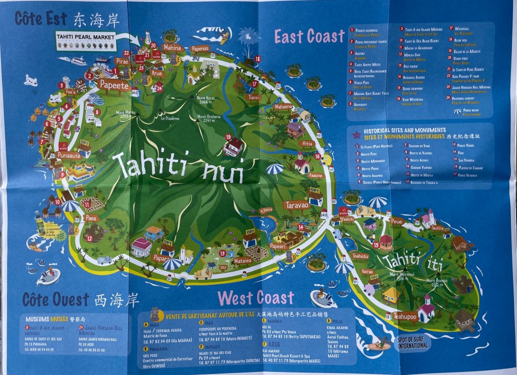
Volcanically formed about a million years ago (don’t you love stories that go back before humans arrived on the scene?) Tahiti actually consists of two major land masses – Tahiti Nui, where Papeete is located, and Tahiti Iti, a smaller but attached land mass to the south. [Fun fact: The surfing competition of the 2024 Olympics took place off Teahupo’o, a beach located on Tahiti Iti.]
Fun tourist map the likes of which Alfred Agate couldn’t even imagine!
But Tahiti is just one of many islands that comprise the Society Islands (Mo’orea, Raiatea, Bora Bora, Taha’a and Huahine are some of the next biggest.) This island group was named by Captain James Cook, supposedly to honor the Royal Society who bankrolled his 1769 voyage of exploration. Today, along with the Tuamotus, Marquesas, Gambier and Austral island groups, these archipelagos comprise what is today known as French Polynesia, one of the remaining overseas colonies of France.
Current thinking is that Tahiti was first settled around 500 BCE. Originating in what is today considered Southeast Asia (think Taiwan, Indonesia, Singapore) these proto-Polynesians were skilled sailors and navigators who island-hopped to Fiji, Samoa and Tonga in outrigger canoes that were up to 90 feet long and could transport people, animals and supplies.
Theirs was a complex society, a clan-based system with a hierarchy of chiefs and nobles and religious leaders. Their culture, language, art, ritual, dance and music would be disseminated throughout what is today considered Polynesia.
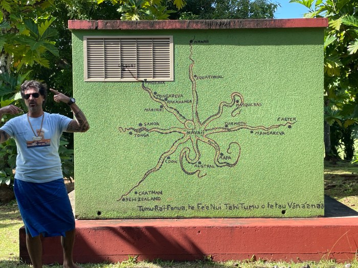
Tumu-Ra’i-Fenua or the Grand Octopus of Prosperity. This image represents the Polynesian method of navigational wayfinding. The octopus’ head, “Havai’i”, is centered on the island of Raiatea in what is today’s French Polynesia. (Tahiti is just to the east, near Tuamotu.)
It’s not clear exactly when Tahiti was first visited by Europeans or by whom – Spanish explorer Juan Fernandez might have been the first to land in the 1570s, but then some think it was a Portuguese explorer Pedro Fernandes de Queiros in 1606. The historical record is also unclear about what happened next, until 1767 when British Captain Samuel Wallis in the HMS Dolphin, definitively landed in Matavai Bay in Tahiti and, using his guns, steel (and probably a few germs) forced the local Chief, Oberea, to, uh, cooperate with the British.
Ahem.
The next year, the French explorer Louis de Bougainville anchored his ships La Bordeuse and Etoile off Tahiti for about 10 days and was apparently favorably impressed with the welcome he received from the Tahitians. (Paul Theroux, in his curmudgeonly book These Happy Isles of Oceania, tells a likely apocryphal story about this visit, when a “barebreasted Tahitian girl climbed from her canoe to a French ship under the hot-eyed gaze of 400 French sailors who had not seen any woman at all for over six months. She stepped on the quarterdeck where she slipped the flimsy cloth pareu from her hips and stood utterly naked and smiling at the men.” And thus the Edenic myth of Tahiti began. Sigh.)
1769 was Captain James Cook’s first visit, in the HMS Endeavour, to observe the transit of Venus. (He would return twice more in the 1770s.)
1787 is of course the year the infamous Captain William Bligh would dock his HMS Bounty at Point Venus and spend five months collecting breadfruit plants in an unsuccessful attempt to find cheap food with which to feed enslaved Caribbean sugarcane workers. And yes, Mutiny on the Bounty was a real thing (though there are those who take great exception with this enduring portrayal of Bligh. A gifted navigator, there was more to him than just all the floggings he ordered . . .)
By the end of the 18th century, whalers had expanded their hunts into the Southern Ocean and Tahiti was a popular stop for resupplying their ships. The Tahitian people quickly learned how to trade with the Europeans, and a flourishing economy of weapons, iron, alcohol and prostitution was established.
In 1797, the first missionaries landed to convert the “heathens.” Today, most Tahitians identify as Christians.
When the US Exploring Expedition arrived in September 1839, Tahitian culture had been irrevocably changed. For starters, the population is thought to have plummeted from an estimated 180,000 to about 8,000. And by the time the USXX showed up, Christian missionaries had made their mark — nudity was banned, as were tattoos, dances and other rituals.
Still, our Alfred Agate was able to create numerous images of Tahitians going about their daily lives. And I was able to see another site from aboard ship that Alfred Agate had also seen and drawn from almost the same vantage point:
Taloo Bay, Eimeo, engraving from a sketch by Alfred Agate, October 1839Oponohu Bay, Mo’orea 2024 (formerly Taloo Bay, Eimeo) Photo taken by James Walters
Tahitian girl with the hau, sketch by Alfred Agate, September 1839 From The Narrative of the US Exploring Expedition, volume 2
Today, you won’t see anyone wearing the hau, but you will find numerous crafts made with pandanus leaves in the same braided fashion:
The hat on the man below was likely woven from pandanus:
Tahitian man in his trading canoe, sketch by Alfred Agate, September 1839 From The Narrative of the US Exploring Expedition, volume 2
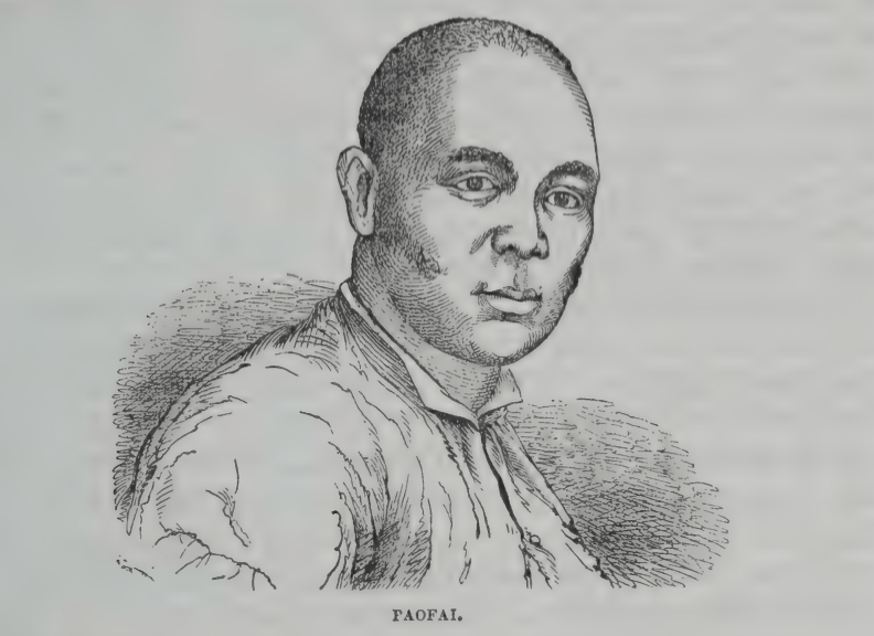
Now, below is an example of Alfred Agate’s artistry being deployed as a form of diplomacy. This is a portrait of Paofai, a chief and an advisor to Queen Pomare IV. Expedition leader Lt. Charles Wilkes wanted a meeting with Queen Pomare to present grievances from US sailing crews regarding their treatment in Tahiti. The Queen was due to give birth so was unable to meet, but sent Paofai as her emissary. Having Agate sketch a portrait of local leaders was a tactic Wilkes would employ on numerous occasions to encourage good feelings and cooperation:
Paofai, Tahitian chief. Sketch by Alfred Agate, September 1839 From The Narrative of the US Exploring Expedition, volume 2
And if you slog through volume 2 of Charles Wilkes’ Narrative of the US Exploring Expedition, you’ll read the following description of Paofai, which exemplifies Wilkes’ confusing interpretations and style of writing: “Paofai, a chief who holds the office of chief judge, and who is generally considered as the ablest and most clear-headed man in the nation, is accused of covetousness, and a propensity to intrigue.”
Finally, here are some more Agate images of daily Tahitian life from the Narrative . As you can see, for the most part the people are dressed in demure, European-style clothes.
Check back soon for Posts #8 and 9 and learn all about the realities of tall ship sailing, kava (a traditional intoxicant) and a Tongan umu (feast).
I’ve received a number of queries asking me to compare the Bark Europa, the ship I’ll be sailing on, to the ship that Alfred Agate was on for the US Exploring Expedition.
First, Alfred was on a total of three ships during the course of the US XX.
He started on the USS Relief, a supply ship that was 109’ long with a 30’ beam.
Commanded by Lt. Andrew K. Long, the Relief was not built for speed. But then, it was meant to be a storeship, so what could you expect? Still, hersluggishness infuriated Lt. Charles Wilkes and after berating Lt. Long mercilessly for months (as much as one could do from another ship with no radio), and after the ship was almost wrecked off Noir Island, Wilkes sent the ship home from the port of Callao. (Fun fact that gets grosser in some accounts – when the Relief was fumigated in Callao, anywhere from 3 – 8 barrels of dead rats were unloaded from her hold.)
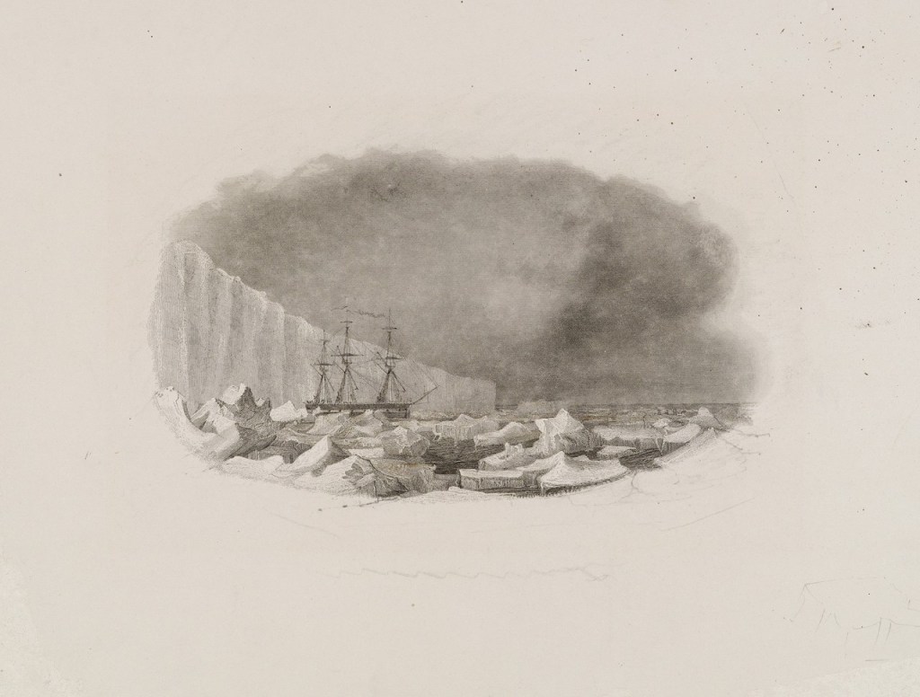
Here is Alfred Agate’s rendition of the USS Relief struggling off Noir Island in the Straits of Magellan, February 1839. Courtesy of the Naval History and Heritage Command
Alfred Agate and William Rich, the naturalist, are transferred to the USS Peacock at Callao.
The USS Peacock was a sloop-of-war, 119’ (36m) long with a 32’ (10m) beam.
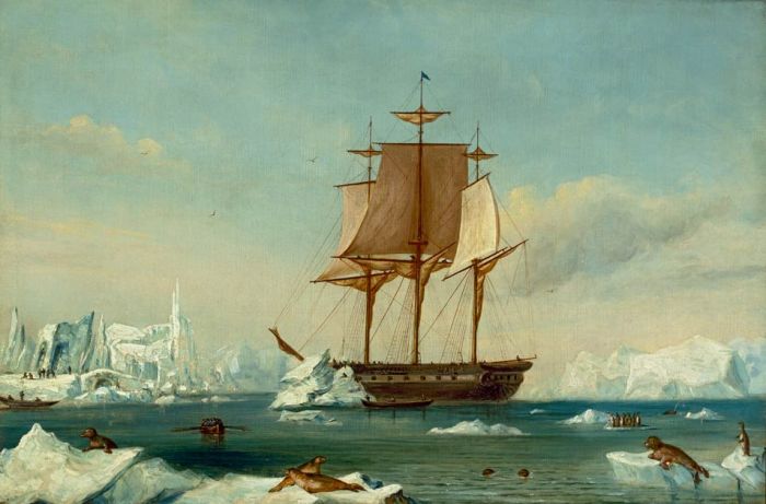
USS Peacock drifting listlessly in Antarctic waters, c. 1839 This image was likely sketched by Lt. Wilkes and then cleaned up by Alfred Agate later as Agate did not embark on either Antarctic mission of the US XX. Courtesy of the Smithsonian Institution
Lt. William Hudson was the very capable commander who eventually, as it seems did everyone, got on Wilkes’ bad side.
Alfred was on the Peacock until it was wrecked on or about July 16, 1840 while trying to cross the bar into the Columbia River. All hands were saved, but Alfred is said to have lost many illustrations on his escape from the sinking ship.
Wreck of the USS Peacock at the mouth of the Columbia River, c. 1840 by Alfred Agate Courtesy of the Naval History and Heritage Command
From there, after some overland expeditions in southern Oregon and northern California (during which Alfred got so ill from “fever and ague” that he had to be transported to San Francisco for treatment.) At this point, he was placed on the USS Vincennes, the flagship of the Expedition and the one under Lt. Charles Wilkes’ direct command.
USS Vincennes in Disappointment Bay, attributed to Lt. Charles Wilkes, c. 1840 Courtesy of the Smithsonian Institution
The Vincennes, also a sloop-of-war, was 127’ (39m) with a beam of 34’ (11m).
In comparison to the three ships listed above, the Bark Europa is a three-masted steel barque, 131’ (40m) long with a beam of 25’ (7.5m). And of course, unlike all the ships on the US Exploring Expedition, she is equipped with engines. However, unlike the Europa, the two sloops-of-war were equipped with numerous cannons of various sizes. These were used to frighten the various native peoples to “encourage” them to cooperate with the demands of the Americans and to retaliate against said natives when they did not.
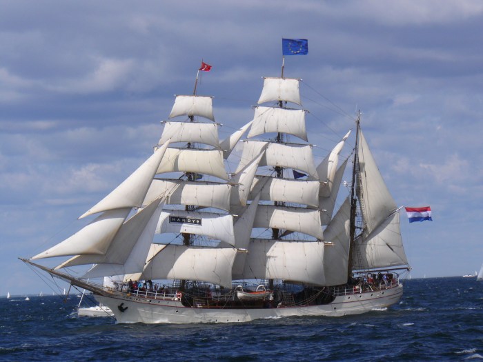
The Bark Europa in full sail, c. 2007. Courtesy of Wikimedia Commons
This is likely to be my last post for a while, as I am about to board the Europa in less than an hour. But I will post again!
If you haven’t already subscribed and are interested in following this journey, you can do so here:
This is just a quick post to share an Alfred Agate illustration that has hardly changed at all in 184 years.
Eimeo as seen from Papeete, Tahiti c. 1840. Watercolor by Alfred Agate Courtesy of the Smithsonian InstitutionMo’orea as seen from Papeete, Tahiti in 2024. Photograph by John Curvan
The USXX arrived in Tahiti in late September 1839, and Alfred Agate was on the USS Peacock, commanded by Captain William L. Hudson.
The four remaining ships of the Expedition were all together at this point and anchored in the bay of Papeete. Lt. Charles Wilkes was busy sending out surveying boats to map the coast of Tahiti and its smaller islands, take soundings of many of the bays, and make tidal and other observations. [You’ll recall that the USXX departed Hampton Roads, Virginia with six ships in August of 1838. The USS Seagull was lost somewhere around Cape Horn, and Wilkes sent the USS Relief home from Orange Bay, Tierra del Fuego because it was slow and unwieldy, plus it was an opportunity to rid himself of crew members and scientifics he thought were difficult or threatening to his authority.]
In 1839, the island in Agate’s watercolor was called Eimeo. Located about 10 miles northwest of the capital city of Papeete, Tahiti, today it is called Mo’orea and is about a 30-minute ferry ride away.
Mo’orea means “Yellow Lizard” in Tahitian. Now exactly why it used to be called Eimeo and when and why the name changed to Mo’orea is something I have not been able to discover. (My excuse is that the Internet here is slow and all the local people I have asked thus far assert that I am mistaken: “Oh no, we have always been Mo’orea” is the general reponse. But I will find this answer!)
Today, Mo’orea is considered a honeymoon paradise and one of the most beautiful islands in the South Pacific. About three years after the US XX left, France took over Tahiti and many of the other islands in the area. They’d fight several wars with the local people, taking over several other island chains in the 19th century. Today, this collection of islands chains is called French Polynesia, and is the last of France’s global empire.
Tahiti and Mo’orea are part of the so-called Society Islands archipelago. (I say so-called because they were named by Captain James Cook in 1769 when he visited here on his first voyage with the mission of recording the transit of Venus. It is said he named them after The Royal Society of London for Improving Natural Knowledge, the sponsor of that voyage.)
[Sidebar – I am continually amazed at the utter chutzpah of these European explorers who “discovered” places that clearly had people already living there and yet blithely renamed them after their sponsors, their wives, or the sailor who first sighted it. Many of the islands in French Polynesia have several names, as they were named and renamed by the various Europeans who visited the islands. As if the people living there had no say in the matter! ]
One more thing about these two images of Eimeo/Mo’orea — the fact that the outline of the island is so very accurate lends credence to the theory that both Alfred Agate and his fellow illustrator Joseph Drayton made use of the the Camera Lucida:
Some may feel that this was “cheating,” but when it is your job to be as quick and accurate as possible in less than optimal conditions, you’ve gotta do what you’ve gotta do.
If you haven’t already subscribed and are interested in following this journey, you can do so here:
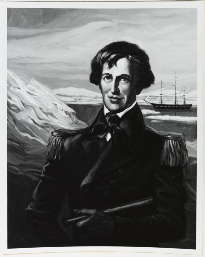
Lt. Charles Wilkes, by Edward M. Stevenson, CDR USNR-R Courtesy of the Naval History and Heritage Command
Today’s post is the fourth in this series detailing my 2024 voyage to the South Pacific (click to see posts 1, 2 and 3). It will give you a little insight into Lt. Charles Wilkes, the complicated leader of US Exploring Expedition of 1838 – 1842. You’ll also get a glimpse of what life must have been like for Alfred Agate on this four-year voyage to edge of the world with a leader like this.
Joye Leonhard’s biography of Wilkes in Magnificent Voyagers, sums him up as “conceited, domineering and arrogant.” Richard J. King, in his book Ahab’s Rolling Sea: A Natural History of Moby Dick, describes him as “an enormously capable, prolific, pompous prick.” Nathaniel Philbrick notes that Wilkes’ nickname among his officers and crew was “the Stormy Petrel,” a bird so called because its appearance portends stormy, rough weather.
You get the picture. However, without Wilkes’ ambition and determination, the USXX likely would never have left the dock. He was both the best and the worst person to put in charge.
There is a theory, one I can thoroughly get behind, that Charles Wilkes was the model for Herman Melville’s Captain Ahab. Wilkes’ blind intensity, his single-minded drive, and his numerous abuses of power (for which he faced several courts martial upon his return) certainly can be seen in the fictional Ahab’s obsessive pursuit of Moby Dick. We know that in 1847 Melville purchased the entire five-volume Narrative of the US Exploring Expedition (illustrated in part by Alfred Agate!) and quoted from it extensively in Moby Dick.
But let’s dig a little deeper . . .
Charles Wilkes was well-educated, and a talented surveyor/navigator. Born in New York City in 1798, his mother died when he was very young and he and his siblings were initially raised by his aunt Elizabeth Ann Seton. (Yes, THAT Elizabeth Ann Seton, the first American saint, sanctified in 1974!)
St. Elizabeth Ann Seton by Amabilia Fillichi Public Domain, courtesy of Wikimedia
However, young Wilkes would get sent to boarding school at the tender age of 5, and by the age of 17 he had joined the US Navy as a midshipman. In between voyages, he would come back to New York City and study math, art and engineering at Columbia University, as well as Hydrology (the measurement and charting of oceans) with Ferdinand Hassler, the first Superintendent of the Coast Guard Survey. Wilkes also befriended the legendary Nathaniel Bowditch, mathematician, astronomer and author of the essential New American Practical Navigator. (Often considered the father of modern maritime navigation, Bowditch’s influence is still felt today, as it is said that every US navy vessel still carries a copy of his book.)
Promoted to Lieutenant in 1826, Wilkes would receive accolades for his excellent work helping to survey and chart Narragansett Bay in 1832 (no doubt in part due to his informal studies with Bowditch.)
Chart of Narraganset Bay Surveyed in 1832 by Capt. Alex. L. Wadsworth, Lieut. Thos. R. Gedney, Charles Wilkes Jr. & Geo. S. Blake Of the U.S. Navy . By order of the Honr. Levi Woodbury, Secretary of the Navy
I would be remiss if I didn’t include a shout-out here to his wife, Jane Renwick Wilkes. They married in 1826, just before Wilkes was promoted. By most accounts, she was intelligent, savvy, and skilled at diplomacy. The love of his life (it is said,) they had known each other since they were children. She moderated his moods and smoothed the social path for him. Moreover, she was his most trusted confidante, and her absence from his life during his most challenging assignment no doubt contributed to many of his difficulties during the USXX.
Jane Jefferies Renwick Wilkes c. 1826 Courtesy of the Naval History and Heritage Command
In 1833, Wilkes would be put in charge of the US Navy Department of Charts and Instruments (later to evolve into the Naval Observatory and Hydrographic Office.) Because of his skill and knowledge, in 1836 he was tapped to help outfit the US XX. He traveled to Europe to purchase the latest in navigational instruments for the Expedition. It wasn’t until March of 1838 that he was given the command – and this only after several others (of higher rank) had been appointed but quickly resigned.
When Wilkes finally left Hampton Roads, Virginia on August 18, 1838, leading the most ambitious exploring expedition ever sent out by the US Government, he was the commander of the USS Vincennes, the flagship of the Expedition. He left behind his beloved Jane, their 4-week old daughter, and three other children. Though communication was extremely uncertain and unpredictable throughout the four-year voyage, Jane and Charles Wilkes would maintain a prolific correspondence. You can read many of these letters held at the Library of Congress here.
The Expedition would test Wilkes in numerous ways – he’d lose two ships, over two dozen sailors and officers to death and desertion, and massacre a village of native people on Malolo Island, Fiji, just to name a few disasters. (Oh yes, more on this Massacre at Malolo to come.) His officers would turn on him, and he would bring charges against at least four of them. They, in turn, filed charges against him and Wilkes returned to the US in 1842 not as a triumphant explorer, but under the shadow of several courts martial. (He was only convicted of one charge, though – illegally punishing his crew through excessive flogging.)
Wilkes would then take over the writing and publishing of the expedition Narrative, with Alfred Agate in charge of the illustrations for the first two volumes. Its first printing was preposterously expensive and only 100 copies were published. However, Wilkes somehow managed to get the US Government to agree to give him the copyright for it, while still getting them pay for the entire endeavor.
Unfortunately, writing was not one of his talents and he mostly cribbed the Narrative from the logbooks of his officers, so the choppy style takes away from the overall excitement of the story. The initial printing of the five portentous tomes were mostly relegated to libraries. Despite this, the Narrative slowly caught the imagination of the public, and went through fifteen printings over the next decade and a half. Should you be interested, you can read the entire thing online here.
At the same time, Wilkes was preparing the Expedition’s vast collections for display, first at the US Patent Office Building and then as the opening exhibit for the new Smithsonian Museum. It’s thanks to him that many of the live plants brought back survived, and to this day, descendants of this flora can still, remarkably, be found in the US Botanic Garden in Washington, DC.
In 1857, the United States Exploring Expedition or Wilkes Expedition collections had been transferred from the US Patent Office to the Smithsonian Museum Courtesy of the Smithsonian Institution
Wilkes embarked on extensive lecture tours as well, drumming up interest and support for further publications. (In all, there were over 10 books relating to the Expedition and the scientific discoveries it contributed to.)
Wilkes would remain on active duty in the Navy, serving in the Civil War as commander of the USS San Jacinto. In 1861, he almost started a war between the US and Great Britain when he captured two British commissioners from the RMS Trent who had been sent to meet with the Confederates and were on their way back to England. Long story short, President Lincoln had to discipline Wilkes for this (though privately he had been thrilled at the capture and Wilkes had been officially thanked by Congress for his actions.) You can read more about it here.
Unbowed, Wilkes was court martialed a few more times before he was finally retired in 1866, and was at long last promoted to rear Admiral.
He wrote an autobiography (that wasn’t published until 1978,) and died in 1877. He is buried in Arlington National Cemetery and on the reverse of his headstone it says “He discovered the Antarctic Continent. January 19, 1840.”
Next post will find us in the islands of Tahiti!
If you haven’t already subscribed and are interested in following this journey, you can do so here:
This is the third of the series documenting my Summer 2024 voyage to the South Pacific. See here for my previous post.
Today’s post will give a blog-length history of the US Exploring Expedition of 1838 – 1842 (aka the US XX). However, if you really want an excellent, in-depth study, I highly recommend reading Nathaniel Philbrick’s Sea of Glory. He does a magnificent job of synthesizing previous histories and making a corking good story of it all:
Known by numerous names – South Seas Surveying and Exploring Expedition, the US South Seas Exploring Expedition, the Charles Wilkes Expedition, it took over 10 years for this expedition to come to fruition.
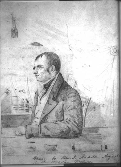
Its inspiration is often laid at the feet of Captain John Cleves Symmes, Jr, a curious veteran of the War of 1812 (and nephew of a Revolutionary War Colonel of the same name). Somehow, Symmes came to believe that the world was hollow and that the entrance to this undiscovered realm could be accessed through the South Pole.
I include John James Audubon’s rough sketch of Captain Symmes here only because Audubon is intimately connected to Ossining, having engaged our own Robert Havell to produce the engravings for his Birds of America in the 1820s & ‘30s. And I love finding these connections!
In 1818, Symmes boldly mailed out 500 copies of his “Circular No. 1” in which he stated:
“I declare the earth is hollow, and habitable within; containing a number of solid concentrick spheres, one within the other, and that it is open at the poles 12 or 16 degrees; I pledge my life in support of this truth, and am ready to explore the hollow, if the world will support and aid me in the undertaking.”
This “Holes in the Poles” theory was not met with great enthusiasm, but it did attract some attention, perhaps most importantly that of New England merchants and whalers. They loved the idea of an expedition that would explore the South Seas, possibly find them undiscovered whaling and sealing grounds, create accurate charts and maps of the area, and maybe even enter into treaties with the islanders. Thanks to President John Quincy Adams, who believed that “The object of government is the improvement of the condition of those who are parties to the social compact,” Congress passed a resolution in 1828 to send a ship to the Southern Ocean. Congress did not, however, appropriate any funds for it.
President John Quincy Adams by Mathew Brady, c. 1843
[Sidebar on President J. Q. Adams, a president that I only know as a whiny politician from the musical “Bloody Bloody Andrew Jackson.” He had remarkably big ideas and believed that America would be doomed to “perpetual inferiority” if she did not step up and contribute to the world of discovery and knowledge. To that end, he tried to establish universities, museums and observatories. An exploration of this magnitude fit in nicely with his worldview.]
Now, no doubt Adams’ desire to sponsor an expedition to the South Seas was also influenced by the fact that many of his Massachusetts friends included the aforementioned whalers and merchants.
But there was still such distrust in leaders and government left over from America’s colonial experiences that it was hard to get Congress to act on anything “frivolous” like science or exploration. Adams was a one-term President and couldn’t get the US XX together before President Andrew Jackson took over. And as we all know, Andrew Jackson was not at all interested in exploration (unless it was in the US and involved massacring indigenous people,) nor was he interested in education or broadening world knowledge. However, by the end of his second term, Jackson started to think that such an ocean expedition seemed very cool and so got the US Navy involved and encouraged Congress to make it happen.
President Andrew Jackson by Ralph Eleaser Whiteside Earl c. 1835
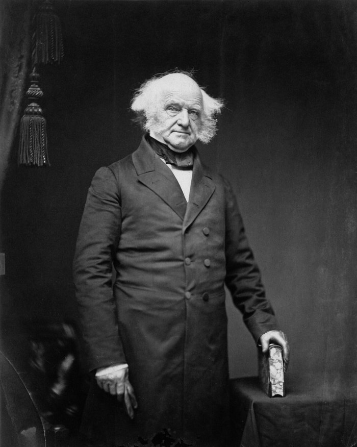
However, it took New Yorker President Martin Van Buren to push it across the start. But by the time things were falling in place for the USXX in the mid-1830s, there had been so much chaos surrounding the expedition, and so many commanders had come and gone, that no Navy man worth his grog wanted command of what began to be called the “Deplorable Expedition.”
President Martin Van Buren by Mathew Brady, c. 1855
Enter Jr. Lt. Charles Wilkes to organize and command the expedition. (Note that Wilkes was a mere Lieutenant though in command of an expedition with six ships. Pretty unheard of in the world of the US Navy, but there was no one else willing to take on this command. His lowly rank would become a great bone of contention for him, since most of the captains of his expedition’s six ships outranked him. This, combined with his inflexible personality and inexperience as a leader would create numerous problems going forward. But more on this in another post.)
Admiral Charles Wilkes (he eventually got promoted!) Courtesy of the Smithsonian Institution
By the time the Expedition shoved off from Hampton Roads, VA on August 18, 1838 its price tag had swelled to over $300,000 (around $10 million in today’s dollars), an astonishing amount for the nation at the time.
In a celebratory speech at the Expedition’s departure, Secretary of the Navy James Paulding would proclaim that the Expedition’s goal was “Not for conquest but for discovery.”
As a reminder, here’s a map of where the Expedition went:
The accomplishments of the Expedition are quite impressive:
Over 280 islands were surveyed
Over 180 charts created (some were still being used during WWII!)
Some 800 miles of Oregon coast and its interior were explored and mapped
Around 1500 miles of Antarctic coast were charted, and the USXX was the likely the first to discover that Antarctica was a separate land mass (there’s still some question on this point) but Charles Wilkes had this factoid chiseled onto his tombstone.
Contributed to the rise of science in America, the evolution of navigation, and the development of the fields of botany and anthropology
The 40-tons worth of plants, animals and artifacts collected becomes the core of the Smithsonian Museum. See more on that here.
Just as a reminder of how large this expedition was, here are the details of six ships that originally comprised it:
Now, for an expedition whose purported purpose was “To extend the bounds of science and promote knowledge,” out of the 400-plus crew, only nine were considered “scientifics.” And our Alfred was considered one of this nine.
Many of them went on to important careers in their chosen fields, adding greatly to the store of knowledge on the natural world. And, thanks to their US XX work, many new species of birds, plants and animals were discovered, collected and studied. Further, thanks to Alfred Agate, records of the unique cultural patterns of dress, tattoos and rituals of the different South Pacific Island nations was documented.
The perils facing the Expedition were great: there were few accurate charts or maps to navigate through the shoals and coral reefs of the islands. The indigenous people were, for the most part, often and understandably hostile towards Europeans coming to their islands and demanding food, water and other supplies. There was no way to communicate between ships except by cannon, lights and flags, meaning that sometimes days or even weeks would go by before they resumed contact. One ship, the Sea Gull, was lost at sea somewhere between Tierra Del Fuego and Valparaiso, Chile during the first year, never to be heard of again. Another ship was wrecked and lost at the mouth of the Columbia River. About 20 of the crew died during the four-year voyage from disease, injury or attacks.
But the Expedition accomplished its mission and put America on the world stage, though perhaps not as spectacularly as President Adams had hoped.
Stay tuned for more about Lt. Charles Wilkes, and stories about the Expedition’s encounters on Tahiti, Tonga and Fiji.
If you haven’t already subscribed and are interested in following this journey, you can do so here:
This is the 2nd post detailing my 2024 voyage to the South Pacific. (Thanks to all of you who responded to my last post asking for more info!)
Herewith I shall answer the essential questions. To wit:
What is it that I’m doing?
My primary impetus for this expedition is to follow in the wake of the artist Alfred Agate, born in Sparta village (today’s Ossining) in 1812.
I am constantly amazed by how the local can connect us to the world. I mean, local history is the bridge that gets you from your neighborhood in Ossining to Tahiti, to Fiji, to Antarctica and beyond. Plus, let’s face it, history is often taught in a rather remote way, dealing with Great Men, dates, wars and empires – things that are grand and far removed from our everyday experience. I think the more we can weave these threads of local connection into the global fabric, the more interesting history becomes, and the tighter our understanding and bonds become with people and cultures around the world.
It’s my hope that I can make the life of Alfred Agate and his experience on the US Exploring Expedition of 1838 – 1842 not only more immediate, but also relevant to our understanding of the world today. Because understanding the past can help us learn from it and move this knowledge forward to do things better in the future.
2. Where am I going?
On July 3, 2024, I’ll be embarking on the Bark Europa from the port of Papeete, Tahiti (French Polynesia) for a 35-day journey to the Fiji Islands, by way of Tonga and whatever other islands the wind leads us to. Our precise route will be determined by the Captain, the weather, and the permits of the local authorities.
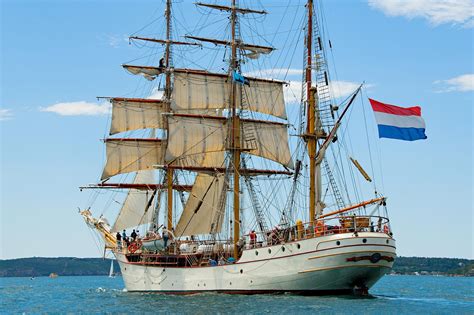
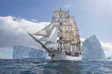
Beauty Shot of the Bark Europa
3. How am I getting there?
What exactly is this Bark Europa of which I speak? Well, she’s a square-rigged, steel-hulled barque that sails under the flag of the Netherlands and is owned and operated by a Dutch company.
Sailing a variety of routes, the Europa often spends her summers in the Antarctic and the Southern Ocean. (As I write this, she just left Pitcairn Island, home to the HMS Bounty mutineers c. 1780s, and South Georgia Island, where Ernest Shackleton landed in 1916 after an 800-mile journey from Elephant Island to arrange the rescue of his crew. Yeah, I might be a little obsessed with the Southern Ocean . . .)
This past fall, the opportunity arose for me to sign on as voyage crew on the Bark Europa on this Tahiti-Tonga-Fiji route. Deep into my obsession with Alfred Agate and the USXX, it seemed like a sign. And sometimes, you just have to say yes to the universe.
Now, for my sailing experts (and to avoid sounding like the neophyte I am regarding all things sail), here is some text lifted in its entirety from the Bark Europa website giving the nitty gritty details on the ship:
Rigged as a bark, the Europa carries twelve square sails in total: six on both the fore and the main mast. The mizzen mast carries the spanker and the gaff topsail. Moreover, she carries ten staysails, to be found between the masts and between the jibboom and the foremast. Sailing broad reach in seas with winds up to 5 Beaufort, Europa can carry six studding sails. In total, a huge area of canvas that has to be set and manned by a lot of hands.
When not under sail, Europa has two Caterpillar 380 HP diesels driving two propellers. For manoeuvring, the ship also has a DAF 180 HP engine that drives a bow thruster and the anchor winch. Both are used in shallow waters, when hoisting anchor and when finding a way through the ice. Bunker capacity for diesel fuel is limited and diesel is also needed to drive the generators for electricity.
This, my friends, is not a Carnival Cruise with unlimited umbrella drinks, a Guy Fieri 24-hour burger buffet and luxury Platinum cabins:
My shared berth
No, as a member of the voyage crew, I’ll be standing watch, acting as helmsman/lookout, climbing the rigging, and practicing all those knots I learned when the boys were in Scouts. (I’ll also learn what the spanker and jibboom are!)
It’s also going to be an experience of slow travel and a return to the pre-internet, pre-smartphone world. There’s satellite communication onboard, but that’s it, and I’m told one pays about $1 per KB for email messages, so don’t expect any Instagram or blog posts from me for the duration (unless we should happen upon an internet café!)
Finally, there will be about 65 people aboard, consisting of crew and passengers.
Feel free to leave a comment if there’s something else you want to know!
For my next post I’ll be giving a little history of the US Exploring Expedition and after that, stories and images of Tahiti, Alfred Agate-style.
If you haven’t already subscribed and are interested in following this journey, you can do so here:
You can also follow the route of the Bark Europa here updated in real time.
Soon I shall be heading to sea on the above Dutch-registered, steel-hulled barque as voyage crew to follow in the footsteps of Ossining’s own Alfred Agate, best known as one of two illustrators for the US Exploring Expedition of 1838 – 1842 (USXX).
Wait, what?
“To sea”?
“Voyage crew”?
“Alfred Agate”??
“US Exploring Expedition of 1838 – 1842”???
Oh yes, I hear all your questions. So consider this the first of several blog posts detailing the life of Alfred Agate, the US XX (aka the Largest All-Sail Exploring Expedition You’ve Never Heard Of), and my 21st century pilgrimage on a tall ship.
Today’s post will focus on Alfred Agate, Ossining artist and International Man of Illustration.
Now, truth to tell, I knew nothing about Alfred or his family until I stumbled into the bottom drawer of a filing cabinet at the Ossining Historical Society and learned about this surprisingly influential family of artists.
First, perhaps you’re familiar with this house that still stands at the corner of Hudson and Liberty Streets in the Sparta area of Ossining?
2 Liberty Street, Ossining c. 2023
Built over 200 years ago by Thomas Agate, it is the grand home of one of the first English settlers in Sparta.
[NOTE: much of the following information comes from a 1968 article written by Ossining historian Greta Cornell, Ancestry.com, and Phillip Field Horne’s A Land of Peace.]
Here’s some background: Alfred’s father, Thomas Agate, was born in Sussex, England c. 1775. He came to Sparta in the 1790s with his siblings John, William, Ann & Mary. In about 1795, the Agates purchased two lots of Sparta land from James Drowley’s estate via a Richard Hillier. They were Baptist/Republicans who didn’t believe in the monarchy, so settling in the recently independent colonies must have been a no-brainer for these motivated Brits.
Thomas seems to have been scrappy and ambitious, and according to Philip Horne, kept a “House of Entertainment” in Sparta until about 1811. (Excellent term, no? Sounds like a strip club to me, although it was likely just a tavern.)
In 1795, he married Hannah Stiles and would continue living and prospering in Sparta. After leaving the “entertainment” business, he would run a store in Sparta, manage the Sparta dock, and buy and sell numerous parcels of land in the neighborhood. When copper was discovered practically right under his house in 1820, Thomas Agate was one of the first to invest in the Westchester Copper Mine Company. Unsurprisingly, nearby Agate Street is named after the family, and the house pictured below was still in the family as late as 1960!
6 Agate Avenue In 1959, home of descendant Melodia Agate Foster Wood
Thomas and Hannah would have at least 4 children:
Edward Priestley Agate:
b. August 29, 1798
m. Mary Williams (7 children “all died young”),
d. November 22, 1872
Frederick Stiles Agate:
b. January 29, 1803
Never married
d. May 1, 1844 (buried in Sparta Cemetery)
Harriet Ann Agate Carmichael
b. March 29, 1817
m. Thomas J. Carmichael c. 1835
d. January 12, 1871 (buried in Sparta Cemetery, though his headstone is currently missing)
Alfred Thomas Agate
b. Feb. 14, 1812
m. Elizabeth Hill Kennedy, 1844
d. Jan. 5, 1845 (buried Mt. Olivet Cemetery, Washington DC)
But Frederick, Harriet and of course Alfred are the ones we are most interested in here.
Older brother Frederick was a precocious and artistic child who, at the age of 15 or so, was sent to study art in New York City with John Rubens Smith. Frederick would then teach his siblings Alfred and Harriet the rudiments of oil painting and find them teachers at the National Academy of Design (which Frederick would help found in 1825 with his bosom friend Thomas Seir Cummings, and painter/telegraph inventor Samuel F.B. Morse.)
At the time, historical and portrait painting was a lucrative career – photographs of course did not yet exist, so painted portraits were the only way to capture a person’s likeness.
Alfred studied with Thomas Seir Cummings at the National Academy of Design (NAD), and by the age of 20 he was exhibiting his paintings at their annual exhibition. By 25, he had his own studio at 25 Walker Street and churned out portraits – both oil paintings as well as miniatures.
Now, during this time, it’s entirely likely (though I have so far found no concrete evidence of it) that Frederick and Alfred met and socialized with Charles Wilkes, the man who would become the leader of the USXX. Wilkes was a Navy man, a talented artist himself, and, most importantly, a skilled navigator, cartographer and surveyor. It does seem that he took some drawing classes at the NAD during the late 1820s/early 1830s.
This connection will become important when the US XX, an expedition that was about a decade in the making, starts to come together in the late 1830s.
In late 1836 our Alfred is offered a position as illustrator for what was then called the “South Seas Surveying and Exploring Expedition.” Here’s his acceptance letter written to Secretary of the Navy Mahlon Dickerson:
Isn’t his handwriting gorgeous??? Courtesy of the National Archives
Now, as promised, I will expound on the development and purpose of said Expedition in a future post. For now, let us concentrate on young Alfred.
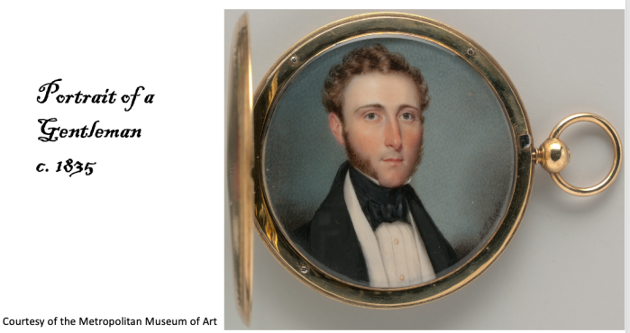
Alfred Agate, c. 1838 Courtesy of the New-York Historical Society
It is believed that brother Frederick painted this portrait just before Alfred left for his voyage to points south. And if you look closely, you can see some subtle iconography in the form of the red sketchbook under Alfred’s left arm and the boat anchors on his fetching gold buttons. Here they are in close up for your amusement:
On August 18, 1838 six ships set off from Norfolk, Virginia on what is often described as the world’s last all-sail exploration expedition:
Approximately 440 men served – 82 officers, 345 sailors, 7 naturalists/scientists and 2 illustrators.
Alfred shared the load with fellow illustrator Joseph Drayton and their importance to the expedition cannot be underestimated. With no ability to photograph anything, it was up to these two artists to document as many plants, animals, landscapes, and people as possible. (Knowing that the US XX sent back about 40 TONS of artifacts, it would have been an Herculean task to document it all.) To that end, to save time, the illustrators often used the Camera Lucida, an optical projection device that some say was developed in the 1600s, though it wasn’t patented until the early 1800s.
Alfred tended to do landscapes and portraits, while Drayton focused on botanical and animal illustrations
Sometimes they worked from sketches of others – many of the officers were passable artists themselves and would give sketches to the illustrators to work from.
During the course of the expedition, hundreds of sketches, watercolors, oils, and later, engravings were made. Just a small number of these were published in the multi-volumed post-expedition Narrative of the USXX.
Sadly, some of Agate’s work was lost in the wreck of the Peacock in 1841, and in a later fire at the Philadelphia publisher’s plant, but there still are a large number extant.
Today, the Naval History and Heritage Command website has digitized and interpreted its significant collection of Alfred’s USXX illustrations. Check it out here.
The route of the USXX is mind-boggling:
And our Alfred sketched wonderful portraits throughout — here are just two of many:
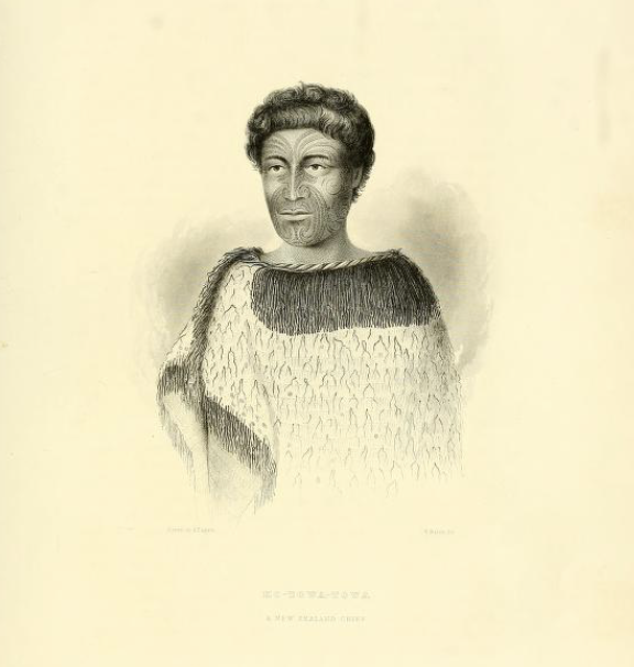
Fijian Chief Ro Veidovi c. 1839Ko-Towa-Towa, New Zealand (Maori) Chief c. 1839
Alfred returned to New York on June 10, 1842, landing at the Brooklyn Navy Yard. After spending a week in quarantine, he likely came back to Ossining to recuperate at his parents’ home on Liberty Street. He was apparently unusually sickly on the expedition (at least, according to Charles Wilkes’ memorial to him). He regained enough strength to relocate to Washington, DC to finalize illustrations for the first volume or two of the Narrative of the US Exploring Expedition written by Charles Wilkes. He also married Elizabeth Hill Kennedy in October 1844. But, tragically, his life was cut short by tuberculosis, that scourge of the 19th century, and he died just a few months after his wedding.
He was fondly remembered by all who knew him, and Senator James A. Pearce of Maryland would honor him with the following words:
The delicacy and sensibility of the man seemed to characterize the productions of his pencil. His drawings, which have been published, and those which remain to be published, show a truthfulness and harmony which stamp him as an artist of the highest order of talent.
RIP Alfred Agate.
Type your email address below to subscribe and make sure you don’t miss the next exciting posts about the USXX and the upcoming voyage I’ll be taking to Tahiti, Tonga & Fiji in July/August 2024 to see the actual sights our Alfred memorialized!
Or click here for the next post in the series on the Bark Europa.