Ossining Rock Shelter

Did you know there’s an indigenous rock shelter accessible to the public just off Route 100??

Ossining Rock Shelter, c. 2023

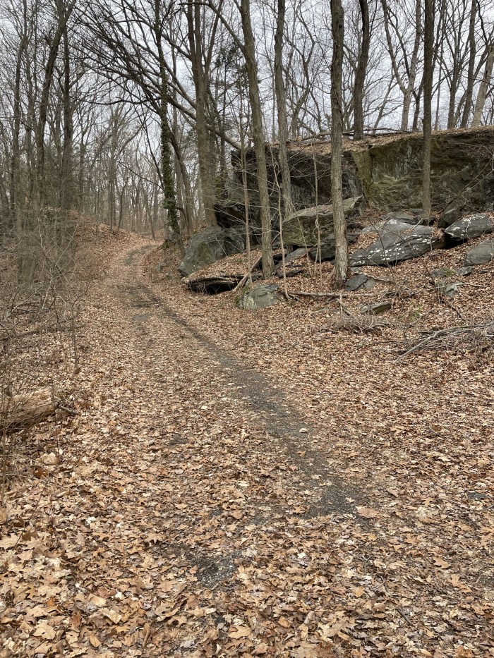
I stumbled upon it a few months ago while doing some other research (frankly, this seems to be how I discover everything cool!)

Standing in front of rock shelter, c. 2023

This one is from the Late Archaic period (that’s about 3,000 years ago) and has been the subject of at least three archeological excavations.

So, let’s investigate it, shall we?

The first excavation took place in 1929 and was conducted by Leslie Verne Case, at the time the Chairman on the Committee of Indian Remains in Westchester County. (What a title!) 

He wrote an article on this dig in the October 1929 Quarterly Bulletin of the Westchester County Historical Society and describes the shelter and its location as follows: 

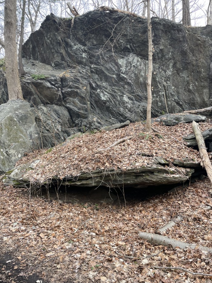
This Algonkian [sic] rock shelter is located two miles from the Hudson River about due east from the village of Ossining. It is one-half mile south of Echo Lake and is near the intersection of the townships of Ossining, Mt. Pleasant and New Castle, but just within the Ossining township. It is about midway between the Saw Mill River Road and the Bronx Parkway Extension now under construction. It is located at about 300 feet elevation above sea level.

The shelter is formed by a great monolith torn by glacial action from the cliff of Fordham gneiss above it. This Archaean ridge extends in nearly a due north and south direction and falls sharply to the east to the Pocantico River a hundred feet below.

Clear as mud right? You can find it from these directions no problem.  

Anyway, Mr. Case was clued on to this site by a Mr. Henry M. Schnarr, who reported that he found fragments of pottery and bone chips more or less on the surface. Case went and found that “A brief inspection clearly proved that the work had not been systematically done and a few hours’ work brought to light” many other artifacts, such as projectile points, scrapers, pottery and a paint pot coated on the inside with a red powder.

Case also noted that this shelter was one of three in the area, the other two famously having been used in the late 19th century by the legendary Leatherman (Google him if you don’t know the story).  Alas, in the intervening century, the other two shelters have been demolished by “the march of time, real estate developments and private enterprises” as Case put it, but one can imagine that they likely held similar artifacts within.

A few years later, some Scout leaders from Troop 44 did some unofficial digging around and found more artifacts, as reported here in the February 23, 1933 edition of the Citizen Register:

The Citizen Register, February 23, 1933
Courtesy of the Ossining Historical Society

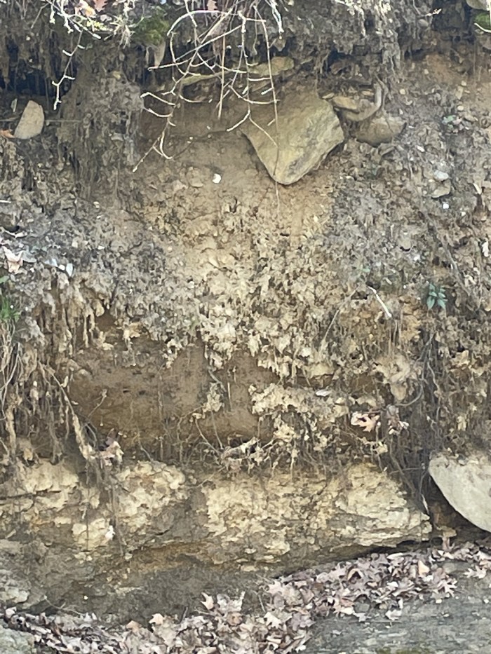
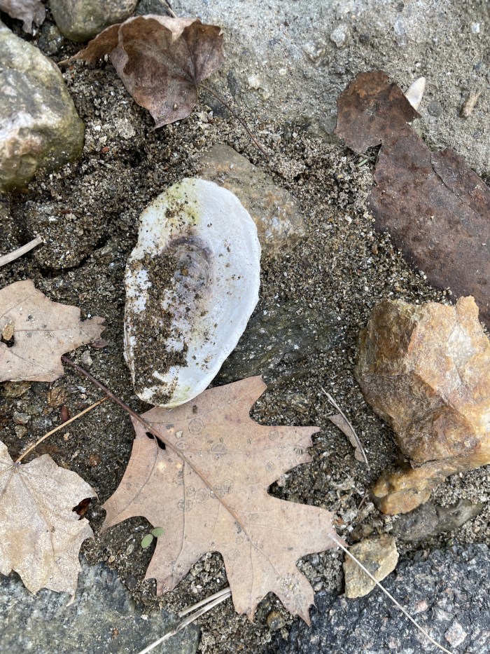
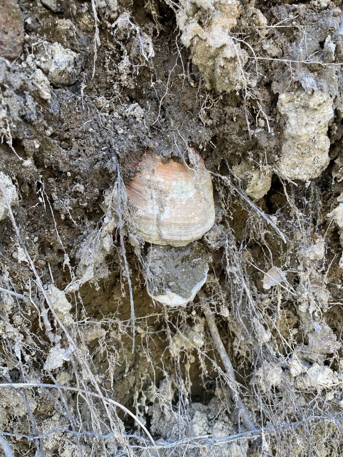
Fast forward to 1982, when an archeologist named Stuart Fiedel spent two seasons excavating the site with his SUNY Purchase students.1  Digging down deeper, and using more modern techniques than Case or the Scout leaders had, Fiedel and his group found an assortment of artifacts from a variety of eras, the oldest being Archaic, but also included were more recent pieces from the Transitional and Woodland periods.  Based on the variety of tools he discovered, Fiedel drew the conclusion that the site had been used for many thousands of years.  The remnants of fire pits and pottery shards were also found, along with bone fragments from deer, turkey, turtle, snake, fish, as well as shells from hickory nuts.

But the most exciting find was a collection of 17 points stashed in a crack in the back wall of the cave.  Some were fully formed, while others were unfinished, but they represented an assortment of styles and uses. Fiedel became convinced that they were the work of a Late Archaic toolmaker who had secreted his cache for some future use.  I could go on and describe the differences seen between the Lackawaxen and Taconic points, the parallel blade edges and hafting notches found thereon, but I shall restrain myself. However, I’m sure you’ll agree that the image of this Late Archaic craftsman, sitting in this very cave, patiently working his bits of chert and quartz and slate into elegant tools is pretty heady stuff.

One thing Fiedel notes in his article is that 95% of all artifacts are perishable, being made of bone, antler, wood and natural fibers.   So, to be able to find anything after all these thousands of years is quite the accomplishment.  It also illustrates how extensive indigenous settlements were in this area, long before Henry Hudson et al showed up.  It’s a concept that I have to really work to get my mind around, to unlearn the belief that European explorers “discovered” America.  Because while they may not have known of it, the people who had been living here for thousands of years obviously did.

And just because I made the effort, here’s what the view from inside the rock shelter looks like. Thousands of years have caused this cave to fill up with dirt and leaves, but imagine what it could have looked like before all that silt flowed in. As it was, I could almost sit up inside to take this picture:

1 “A Late Archaic Cache from the Ossining Rockshelter” by Stuart J. Fiedel. The Bulletin and Journal of Archeology for New York State, Number 88, Spring 1984

Did I stumble upon a Native American Shell Midden in the lower Sing Sing Kill?

During Covid, my friend Dorian and I met almost every Saturday to go to the Farmer’s Market, get a coffee at First Village, and walk along the Sing Sing Kill Greenway.  It was a welcome respite from being stuck in our homes teaching via Zoom.

On one of these many excursions, I felt sure I saw a collection of oyster shells poking out from the steep slope across from the pedestrian walkway.  Knowing that the indigenous people of this area were known to eat a great many oysters and knowing that there are a number of shell middens along this stretch of the Hudson, and knowing that the sea/river level had been higher here at one point long ago, it wasn’t a completely bonkers assumption.

Here’s what first piqued my interest:

It’s a little hard to tell from this picture, but almost all those white things you see are indeed shells – oyster and clam.

Looking down by the water, I saw several shells just lying about:

Then, here’s a close-up of the hillside — you can definitely see shells poking out, yes?

Now what, you may ask, precisely IS a shell midden?  Well, basically, it’s a pile of discarded shells left there by the indigenous people who visited and inhabited these sites over the centuries.  In our area, on the Hudson River, it’s thought the salinity of the river became ideal for oysters around 7,000 years ago. That’s about the age of the oldest oyster that’s been radiocarbon dated around here.

Here’s a picture of one of the middens on Croton Point, not at all far away from Sing Sing Kill:

You can see how there’s a definite band of shells underneath this tree, along with shells scattered all over the surface. Go check this spot out at Croton Point (on the trail behind the Nature Center.)
Photo by Scott Craven

But somehow it took me until very recently to do my due diligence and really try to figure this out.  So, I located the site on a map, took all sorts of pictures of it, and consulted with Dr. Jonathan Lothrop, Curator of Archeology of the NYS Museum in Albany.  (And let me take this opportunity to give him and the whole research department there a huge shoutout for their generosity in answering my questions over the years.)

First, I must confess that I’ve always had a fascination with radiocarbon dating – that is, the 1940s-era technology of determining the age of an organic artifact by measuring its radiocarbon levels.  Since I learned of this technique in my “Tell Me Why” book when I was 10, I’ve had a burning desire to find an artifact that could be carbon-dated.

Now, I know from writing my book on Croton Point (shameless plug),  oyster shells can be carbon dated fairly successfully.  In fact, in the 1960s, some shells found in a Croton Point midden were radiocarbon dated by Louis A. Brennan, and that’s how we know for (pretty) sure that there were humans inhabiting the area and eating oysters by the bushel at least 6,000 years ago.

And there were definitely shells to be retrieved and possibly dated from the Kill. I reached out to an archeologist friend and asked her where one could get such an artifact dated.  She was skeptical, because context is essential in dating a site, but she gave me the name of Beta Analytics, a Miami-based radiocarbon dating lab.  I sent off an email to them, trying to temper my wild enthusiasm and not sound like a nut, and asked how much it would cost to radiocarbon date two shells (because why not, right?)  They took me seriously and sent back an official quote of $675 per artifact.

But before I got too crazy, I sent a carefully composed email with photos to Dr. Lothrop and asked his opinion.  Was it possible I had found something significant?  And if I retrieved samples, would they be worth spending this kind of money on?

His response was swift and measured.  And while I was pretty sure my zeal to accomplish this childhood dream of mine was clouding the skepticism required for any reasonable investigation, he let me down gently and gave me some excellent advice for the future.

First, he confirmed that 

“In terms of location, sure it’s entirely possible to encounter a Native American shell midden of some antiquity in this stretch of the Hudson Valley; you are not far from a number of recorded shell midden sites, primarily dating to the Archaic.”

So, yay, it wasn’t totally illogical to think this is an ancient midden.

But then he went on to explain why context is so important in an archeological site and what exactly that means.  You see, so much of how artifacts can be identified and dated (even without the radiocarbon technology) is based on association – what artifacts are found near other artifacts, and how deep one has to dig to find them.  Artifacts include things like cracked rocks (indicating a fire pit), points (or arrowheads), fishing net sinkers and other tools carved from rocks.  Obviously rocks can’t be used to tell us the date of anything because they are as old as time.  (Okay, I exaggerate, but they are far older than any of the humans who chipped them into shapes.)  So the only way we can make sense of such things is to meticulously note what is found where and make educated guesses as to how and when they got there.  The types and shapes of points is a science unto itself, and context is so important there in identifying them with any accuracy. Then and only then, if we’re lucky enough to find some organic artifacts like shells or bones, does it make sense to radiocarbon date them.

And while we might be able to date the oyster shells I found, the place I found them is on an almost perpendicular hillside that has been greatly disturbed by erosion and industry over the centuries. So, who knows where these shells were located originally.

Dr. Lothrop emphasized this in his response:

“Perhaps the biggest issue is, given this very steep slope, there is virtually no chance that what you are observing is “in-situ.” By that I mean that such a steep slope has likely been continually eroding over time since the Ice Age, and anything discarded there by humans would no longer be in its original position (a scenario consistent with the exposed bedrock). From that standpoint, any archaeological material (whether historic or pre-contact) that has not yet been eroded, is not found in a stratigraphically stable environment and therefore lacks stratigraphic integrity and association – a key feature of any archaeological site that might have reasonable research potential.”

Finally, he went on to say

“However equally and perhaps more probable – given the urban setting – is that what you’re seeing is historic food refuse that was discarded on this steep slope, some of which is being exposed by active erosion at the base.”

So, alas, there is no point is spending $675 to date a shell found at this location.  

But, I still want to believe I’ve found the remains of an Archaic or Sint Sink midden, and not the garbage from a 19thcentury oyster house!

Have you ever seen unexplained piles of oysters in our area?