This is just a quick post to share an Alfred Agate illustration that has hardly changed at all in 184 years.
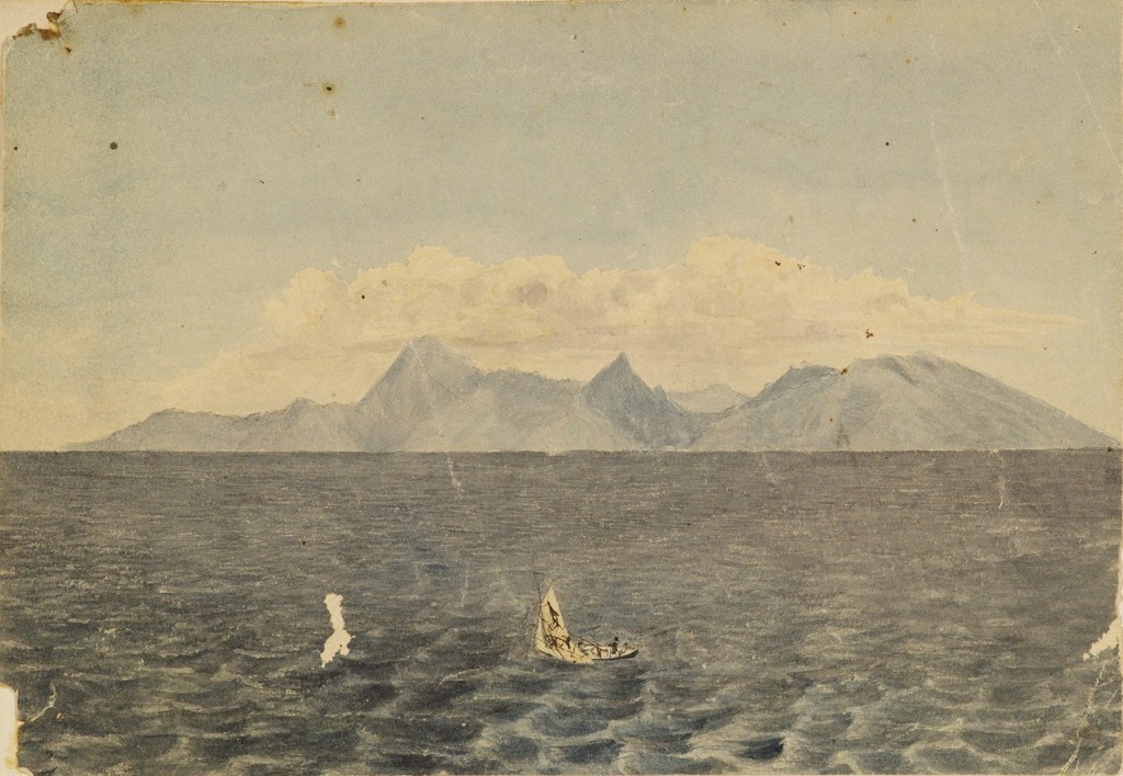
Courtesy of the Smithsonian Institution
Photograph by John Curvan
The USXX arrived in Tahiti in late September 1839, and Alfred Agate was on the USS Peacock, commanded by Captain William L. Hudson.
The four remaining ships of the Expedition were all together at this point and anchored in the bay of Papeete. Lt. Charles Wilkes was busy sending out surveying boats to map the coast of Tahiti and its smaller islands, take soundings of many of the bays, and make tidal and other observations. [You’ll recall that the USXX departed Hampton Roads, Virginia with six ships in August of 1838. The USS Seagull was lost somewhere around Cape Horn, and Wilkes sent the USS Relief home from Orange Bay, Tierra del Fuego because it was slow and unwieldy, plus it was an opportunity to rid himself of crew members and scientifics he thought were difficult or threatening to his authority.]
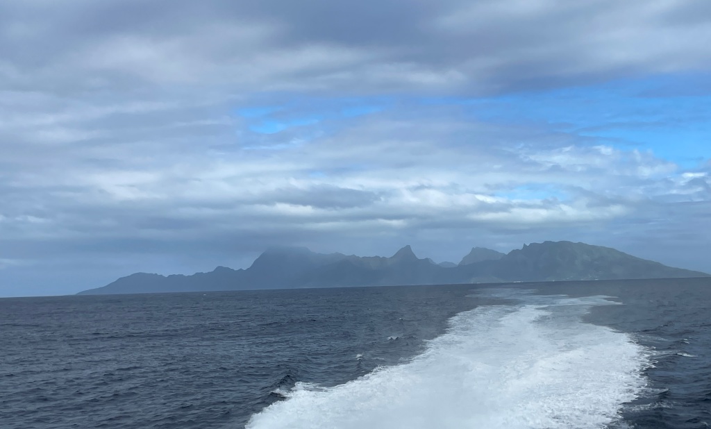
In 1839, the island in Agate’s watercolor was called Eimeo. Located about 10 miles northwest of the capital city of Papeete, Tahiti, today it is called Mo’orea and is about a 30-minute ferry ride away.
Mo’orea means “Yellow Lizard” in Tahitian. Now exactly why it used to be called Eimeo and when and why the name changed to Mo’orea is something I have not been able to discover. (My excuse is that the Internet here is slow and all the local people I have asked thus far assert that I am mistaken: “Oh no, we have always been Mo’orea” is the general reponse. But I will find this answer!)
Today, Mo’orea is considered a honeymoon paradise and one of the most beautiful islands in the South Pacific. About three years after the US XX left, France took over Tahiti and many of the other islands in the area. They’d fight several wars with the local people, taking over several other island chains in the 19th century. Today, this collection of islands chains is called French Polynesia, and is the last of France’s global empire.
Tahiti and Mo’orea are part of the so-called Society Islands archipelago. (I say so-called because they were named by Captain James Cook in 1769 when he visited here on his first voyage with the mission of recording the transit of Venus. It is said he named them after The Royal Society of London for Improving Natural Knowledge, the sponsor of that voyage.)
[Sidebar – I am continually amazed at the utter chutzpah of these European explorers who “discovered” places that clearly had people already living there and yet blithely renamed them after their sponsors, their wives, or the sailor who first sighted it. Many of the islands in French Polynesia have several names, as they were named and renamed by the various Europeans who visited the islands. As if the people living there had no say in the matter! ]
One more thing about these two images of Eimeo/Mo’orea — the fact that the outline of the island is so very accurate lends credence to the theory that both Alfred Agate and his fellow illustrator Joseph Drayton made use of the the Camera Lucida:

Some may feel that this was “cheating,” but when it is your job to be as quick and accurate as possible in less than optimal conditions, you’ve gotta do what you’ve gotta do.
If you haven’t already subscribed and are interested in following this journey, you can do so here:

keep posting!!!
LikeLike